The integration of consumer technology and emergency response reached a somber milestone on March 22, 2026, when an automated alert from an Apple device led search and rescue teams to the site of a fatal aviation accident in the rugged backcountry of Northern California. The pilot, identified by the Placer County Sheriff’s Office as 79-year-old James Wholey, was killed when his Beechcraft A36 Bonanza crashed into the Granite Chief Wilderness. The incident has prompted a massive multi-agency response, the closure of a popular hiking corridor, and a federal investigation that could span the next two years.
According to Elise Soviar, a spokesperson for the Placer County Sheriff’s Office (PCSO), the aircraft was en route to the Truckee Tahoe Airport when it disappeared from radar. The flight, traversing the western shore of Lake Tahoe, encountered difficulties in a region known for its unpredictable mountain weather and treacherous terrain. While the aircraft’s disappearance from radar provided a general area of concern, it was the pilot’s Apple Crash Detection system—a feature embedded in the latest iterations of the iPhone and Apple Watch—that provided the precise coordinates necessary for a rapid deployment.
The Role of Wearable Technology in Modern Search and Rescue
The Apple Crash Detection system is designed to identify high-impact events using a combination of high-g-force accelerometers, gyroscopes, microphones, and barometers. When the system detects what it perceives to be a severe vehicle or impact event, it initiates a countdown; if the user does not respond, the device automatically contacts emergency services and provides GPS coordinates.
In this instance, the technology bypassed the traditional delays associated with manual distress calls or the triangulation of emergency locator transmitters (ELTs), which can sometimes be damaged or muffled in high-impact backcountry crashes. The PCSO confirmed that the alert was received almost simultaneously with the aircraft’s disappearance from radar screens. This digital "handshake" between the pilot’s personal device and the dispatch center allowed Tahoe Nordic Search and Rescue (TNSAR) to mobilize with a degree of geographic certainty that is often missing in wilderness aviation accidents.
While the technology proved effective in locating the site, the outcome underscores the inherent risks of mountain aviation. The Granite Chief Wilderness is a 25,000-acre protected area characterized by steep granite peaks and dense forests, making any rescue or recovery operation a logistical challenge.
Chronology of the Response and Recovery Operation
The timeline of the incident reflects the high-stakes nature of alpine search and rescue. At approximately 3:40 PM on March 22, the PCSO received the automated notification from the Apple device. By that time, the Beechcraft A36 Bonanza had already ceased communication with air traffic control.
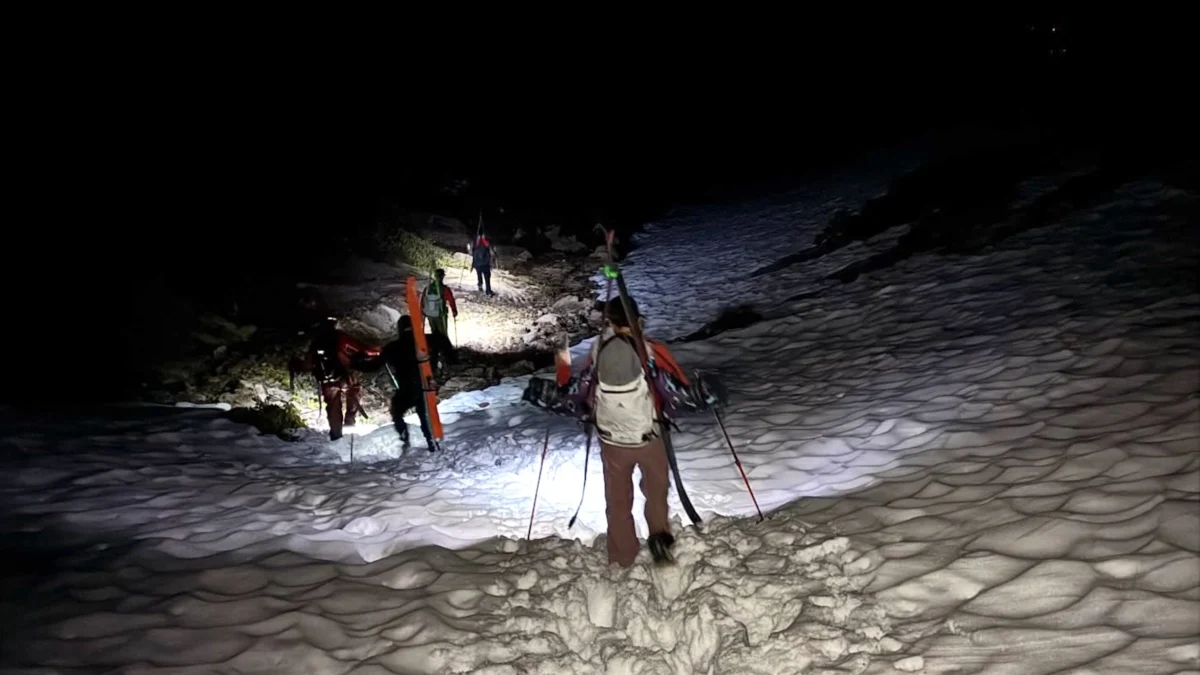
The PCSO immediately activated Tahoe Nordic Search and Rescue, a specialized team trained for high-altitude and winter environments. The response was two-pronged:
- Aerial Insertion: Two TNSAR rescuers were transported via helicopter to the vicinity of the coordinates provided by the crash detection system. Despite the precision of the GPS data, the heavy snowpack and dense canopy necessitated a dangerous hover-exit to reach the ground.
- Ground Support: A larger contingent of more than 20 rescuers began a cross-country trek on skis and snowshoes. This team was supported by heavy machinery, including a snowcat and snowmobiles, to transport equipment and prepare for a potential casualty evacuation.
Upon reaching the site, rescuers confirmed that the pilot had sustained fatal injuries. The focus of the operation then shifted from rescue to recovery and the preservation of the scene for federal investigators.
Federal Investigation and the Beechcraft A36 Bonanza
The National Transportation Safety Board (NTSB) has assumed the lead role in determining the cause of the crash. Keith Holloway, a spokesman for the NTSB, stated that an investigator arrived on the scene on March 25 to begin the "fact-gathering phase."
The aircraft involved, a Beechcraft A36 Bonanza, is a highly regarded six-seat, single-engine aircraft known for its performance and utility. Since its introduction in the late 1960s, the Bonanza series has been a staple of general aviation. However, mountain flying in a single-engine craft requires navigating complex updrafts, downdrafts, and "density altitude" issues that can affect engine performance.
The NTSB investigation will follow a standard protocol:
- Preliminary Report: Expected within 30 days of the accident, this document will outline the factual circumstances of the flight, including weather conditions, pilot experience, and recorded flight path data.
- Fact-Gathering: Investigators will examine the wreckage, engine components, and maintenance records. They will also look into the pilot’s medical history and recent flight activity.
- Final Report: The determination of "probable cause" can take between 12 and 24 months. This report will provide the definitive analysis of whether the crash was a result of mechanical failure, pilot error, environmental factors, or a combination thereof.
"The NTSB does not determine or speculate on the cause of an accident during the on-scene phase," Holloway emphasized. "We are looking at every variable, from the airframe’s integrity to the atmospheric conditions at the time of the impact."
Environmental Impact and Public Safety Closures
In the wake of the accident, the U.S. Forest Service (USFS) took the unusual step of issuing an emergency closure for a 225-acre area surrounding the crash site. This closure includes a significant portion of the Five Lakes Trail, one of the most popular hiking destinations in the Tahoe region.
Lauren Faulkenberry, a representative for the USFS, noted that the closure is currently slated to last until at least April 7, though it could be extended depending on the progress of the NTSB’s work. The decision to close the area was based on three primary factors: investigative integrity, public safety, and environmental protection.
Dan Whitten, a retired search-and-rescue coordinator with 26 years of experience at the San Bernardino County Sheriff’s Department, explained the necessity of such measures. "When an aircraft impacts the ground at high speed, the debris field can be massive," Whitten told Outside. "In a wilderness area with heavy snow, parts of the plane can be buried or scattered over hundreds of yards. If the public enters that area, they can inadvertently move or destroy evidence that is critical to the NTSB’s findings."
Whitten also highlighted the environmental risks. A Beechcraft A36 can carry up to 74 gallons of aviation gasoline (AvGas). "If that plane had a full load of fuel, you’re looking at a hazardous materials situation," Whitten said. "Spilled fuel in a watershed, especially near sensitive alpine lakes like the Five Lakes, requires a specialized cleanup that can’t happen if hikers are walking through the site."
Addressing the Phenomenon of "Disaster Tourism"
Beyond the physical dangers of fuel and debris, authorities are concerned about "disaster tourism." In the age of social media, crash sites often become magnets for individuals seeking to document the wreckage for online platforms.
"Especially when you’re that close to an area like Lake Tahoe with high tourist traffic, disaster tourism is a real issue," Whitten noted. "People don’t realize that a crash site is a scene of a tragedy and a federal investigation site. It is not a hiking destination."
The USFS and PCSO have warned that individuals violating the closure order could face federal charges. The closure allows the NTSB to conduct their work without interference and ensures that the eventual removal of the wreckage—which will likely require a heavy-lift helicopter—can be performed safely.
Broader Implications for Aviation and Technology
The crash in the Granite Chief Wilderness serves as a case study for the evolving relationship between personal technology and emergency services. While Apple’s Crash Detection was designed primarily for automotive accidents, its utility in general aviation is becoming increasingly apparent. For pilots of small aircraft, who often fly in areas with limited radar coverage, such devices may serve as a critical secondary fail-safe.
However, the incident also highlights the limitations of technology. While the device successfully alerted rescuers, it could not prevent the tragedy itself. As the NTSB continues its investigation, the aviation community will be looking for lessons regarding mountain transit and the aging pilot population. James Wholey, at 79, was an experienced pilot, and the final report will likely examine whether age-related factors or mechanical issues played a role in the descent.
For now, the Five Lakes Trail remains silent, save for the work of investigators sifting through the snow. The community of Lake Tahoe and the family of James Wholey await answers, while the technological footprint of the rescue serves as a reminder of how the digital age is reshaping the boundaries of the American wilderness.