
 Walid Sujud Trenggono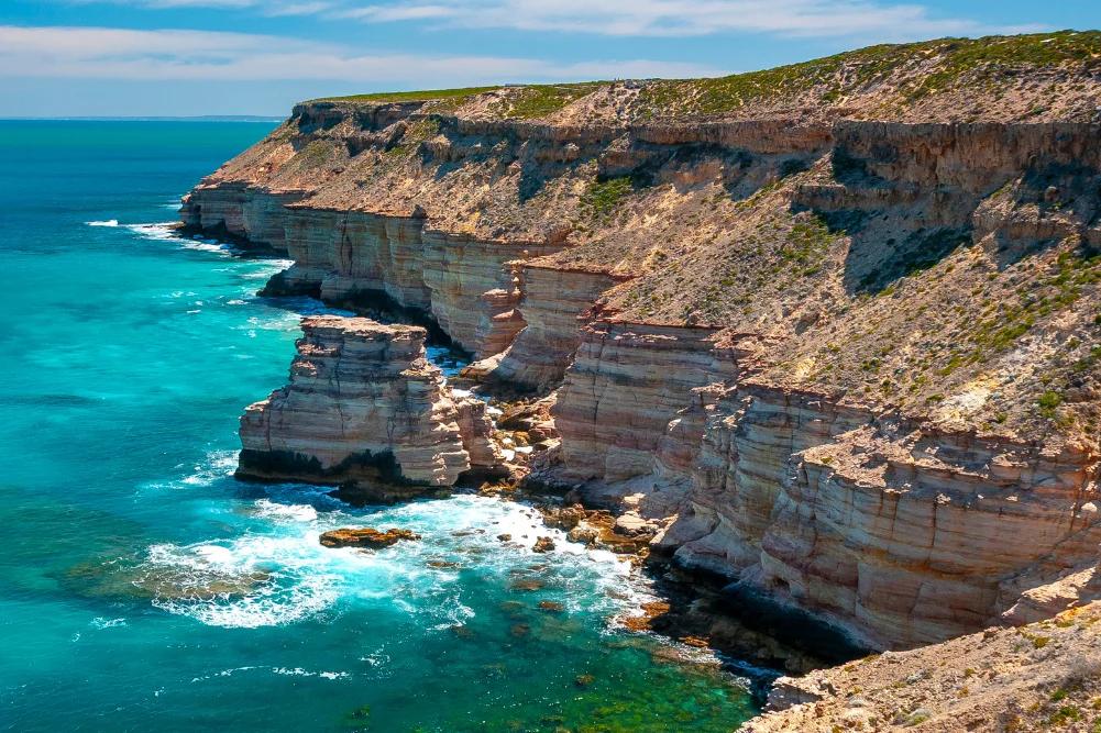
The Indian Ocean Drive, a 277-kilometer stretch of road connecting Lancelin to Dongara, has evolved into one of Western Australia’s most significant tourism corridors. Extending further north toward Kalbarri, this route serves as a gateway to the Coral Coast, a region defined by its unique intersection of maritime history, ancient geological formations, and extraordinary biodiversity. As the final winter rains recede, the landscape undergoes a dramatic transformation, drawing thousands of domestic and international visitors to witness the seasonal wildflower bloom and explore the rugged coastline. This report examines the geographical highlights, historical significance, and the environmental and economic impact of this vital Australian transit-way.
Regional Geography and the Indian Ocean Corridor
The journey typically commences north of Perth, where the landscape shifts from urban sprawl to rolling pastures and coastal shrubland. The Indian Ocean Drive (Route 60) was officially completed in 2010, designed to improve safety and accessibility for travelers who previously relied on the inland Brand Highway. The road winds through a succession of coastal hamlets, each supported by a combination of primary industries—predominantly rock lobster fishing—and seasonal tourism.
Geologically, the region is characterized by the Swan Coastal Plain, a strip of low-lying land between the Indian Ocean and the Darling Scarp. The terrain is marked by shifting sand dunes, limestone outcrops, and salt pans, providing a stark contrast to the azure waters of the coast. The transition from the white sands of Lancelin to the ochre gorges of Kalbarri represents a cross-section of Western Australia’s diverse geomorphology.
Lancelin: The Intersection of Industry and Recreation
Lancelin, known to the Yued Indigenous people as "Wangaree," remains a critical hub for the Western Rock Lobster (Panulirus cygnus) industry. This fishery is one of the most valuable in Australia, contributing hundreds of millions of dollars to the state economy annually. For the tourism sector, Lancelin offers a dual appeal: its calm bays provide sanctuary for marine life, while its massive inland dunes serve as a premier destination for adventure sports.
The Lancelin Island Nature Reserve, located approximately 700 meters offshore, acts as a sanctuary for various seabird species and the occasional Australian sea lion. Beneath the surface, the region’s maritime history is etched into the seafloor, with 14 documented shipwrecks forming part of a recognized dive trail. These wrecks serve as artificial reefs, supporting a complex ecosystem of dhufish, pink snapper, and yellowtail kingfish.
To the north of the town, the sand dunes—stretching for two kilometers—are a major drawcard for sandboarding and off-road vehicle enthusiasts. Local tourism operators report that these dunes are a primary driver of day-trip traffic from Perth, highlighting the importance of proximity to the metropolitan area for regional economic stability.
The Pinnacles: A Geological and Cultural Landmark
Located within Nambung National Park near the town of Cervantes, the Pinnacles Desert is perhaps the most iconic landmark on the Indian Ocean Drive. These thousands of limestone spires, some reaching heights of four meters, were formed approximately 25,000 to 30,000 years ago after the sea receded and left deposits of sea shells. Over millennia, coastal winds removed the surrounding sand, exposing the pillars.
The site holds deep cultural significance for the Yued people. According to Indigenous oral histories, the landscape was shaped by the Wagyl, the rainbow serpent, a central figure in Noongar creation stories. In contrast, early European maritime explorers, specifically Dutch sailors in the 17th century, initially mistook the formations for the ruins of a lost city.
Today, Nambung National Park is a critical site for conservation and tourism research. Western grey kangaroos and a variety of reptile species inhabit the acacia-rich shrubland surrounding the desert. The Pinnacles Desert Loop Drive and associated walking trails allow for managed tourist access, balancing the need for public engagement with the preservation of the fragile limestone structures.
Marine Conservation and Biodiversity in Jurien Bay
Further north, Jurien Bay serves as a focal point for marine conservation. The Jurien Bay Marine Park protects a diverse range of habitats, from extensive seagrass meadows to offshore limestone reefs. The park is most notable for its population of Australian sea lions (Neophoca cinerea), one of the rarest seal species in the world.
Breeding colonies are concentrated on Buller Island, North Fisherman Island, and Essex Rocks. Due to the vulnerable status of the species, access to these islands is strictly regulated. Tour operators provide the only legal means of close interaction, emphasizing the role of "eco-tourism" in funding conservation efforts and raising public awareness.
The marine environment here also supports the Western Rock Lobster industry, with the seagrass meadows providing essential nursery grounds. For recreational visitors, the Jurien Bay Town Beach and the artificial reef at the old jetty offer accessible snorkeling opportunities, featuring interpretive signage designed to educate the public on marine ecology.
Maritime History and the "Gilt Dragon" Legacy
The coastal stretch near Green Head and Leeman is steeped in maritime lore, particularly the 1656 wreck of the Vergulde Draeck (Gilt Dragon). The Dutch East India Company ship struck a reef north of Yanchep, leading to one of the earliest recorded European encounters with the Australian continent. In the 1960s, treasure hunters used Dutch maps and explosives to locate the wreck, an event that eventually led to more stringent maritime archaeology laws in Australia.
Dynamite Bay in Green Head, named following these mid-century salvage efforts, remains a significant site for both history and recreation. The bay’s Yued name, Cuencandjaa, meaning "mouthful of sand," reflects the area’s rugged coastal character. Nearby, the Stockyard Gully Caves provide an inland contrast. These 250-meter-long limestone tunnels were formed by an ancient seabed and served as a crucial watering hole for stockmen driving cattle along the coast in the 19th century. The caves are now a protected reserve, showcasing delicate stalactites and providing habitat for honey possums and various bird species.
Geraldton and the HMAS Sydney II Memorial
As the Indian Ocean Drive merges with the Brand Highway, the city of Geraldton emerges as the regional capital of the Mid West. Geraldton’s identity is inextricably linked to the sea, both as a major port and as a site of historical tragedy.
The HMAS Sydney II Memorial, situated on Mount Scott, commemorates the 645 sailors lost in November 1941 when the cruiser was sunk by the German raider Kormoran during World War II. It remains the greatest single-day loss of life in the history of the Royal Australian Navy. The memorial’s location provides a panoramic view of the coast, serving as a somber reminder of the treacherous nature of the Western Australian waters.
Geraldton also serves as a hub for the study of the Batavia shipwreck (1629), with the Museum of Geraldton housing significant artifacts. The city’s economy is a bellwether for the region, balancing large-scale mining exports with a thriving tourism and hospitality sector.
The Science of Hutt Lagoon and the Kalbarri Gorges
North of Geraldton lies Hutt Lagoon, a 70-square-kilometer salt lake famous for its vivid pink hue. This coloration is the result of the presence of the carotenoid-producing algae Dunaliella salina. This site is not merely a tourist attraction but a significant industrial asset; the lagoon is used for the commercial harvesting of beta-carotene, used in food coloring and vitamin supplements. The intensity of the pink varies according to salinity levels and sunlight, making it a dynamic feature of the landscape.
The journey culminates in Kalbarri, where the Murchison River meets the Indian Ocean. Kalbarri National Park, spanning over 183,000 hectares, features dramatic sandstone cliffs and deep river gorges. The "Nature’s Window" rock formation and the recently constructed Kalbarri Skywalks—two cantilevered platforms hanging 100 meters above the Murchison Gorge—represent significant infrastructure investments aimed at modernizing the regional tourism experience.
In 2010, Jakes Point in Kalbarri was declared a National Surfing Reserve, recognizing its world-class waves and cultural importance to the surfing community. The town itself has successfully transitioned from a quiet fishing outpost to a sophisticated tourism destination, with establishments like Finlay’s Kalbarri emphasizing local produce and sustainable seafood.
Conclusion: Economic Implications and Future Outlook
The Indian Ocean Drive and its northern extensions are more than a scenic route; they are a vital economic artery for Western Australia. The regional tourism industry relies heavily on the seasonal influx of visitors during the wildflower season (July to October), which sees over 12,000 species of plants come into bloom.
Supporting data from Tourism Western Australia suggests that regional travel continues to be a primary driver of economic growth in the Mid West and Gascoyne regions. However, this growth brings challenges, including the need for sustainable waste management, the protection of endangered species like the Australian sea lion, and the maintenance of road infrastructure against the harsh coastal environment.
As travelers continue to seek "nature-based" experiences, the Indian Ocean Drive stands as a premier example of how natural heritage, when managed with a balance of conservation and infrastructure, can sustain regional communities. The transition from the shipwrecks of the 17th century to the skywalks of the 21st century illustrates a region that is deeply aware of its past while actively building a sustainable future.



 Anjar Salim
 Dwi Wanna
 Budi Mulyono
 Lukman Taruna Persada Ramadan
 Chandra Hamzah
 Gabriela Annisa