The Indian Ocean Drive, a premier tourism corridor stretching north from Perth, represents one of Western Australia’s most significant coastal infrastructure projects, providing access to a diverse array of ecological landmarks, maritime history, and Indigenous heritage. Spanning approximately 600 kilometers to the township of Kalbarri, this route traverses the traditional lands of the Yued and Nanda peoples, offering a window into both the ancient geological past of the continent and the burgeoning eco-tourism industry that sustains the regional economy. Following the conclusion of the winter rains, the region undergoes a dramatic transformation as the wildflower season commences, attracting thousands of domestic and international visitors to witness a botanical display that is globally unique in its biodiversity.
Strategic Significance of the Indian Ocean Drive
Completed in 2010 at a cost of approximately $95 million, the Indian Ocean Drive was designed to bypass the inland Brand Highway, linking coastal hamlets and providing a safer, more scenic route for travelers. The road has since become a vital artery for the "Coral Coast" tourism region. According to data from Tourism Western Australia, the Coral Coast attracts over 1.2 million visitors annually, contributing significantly to the state’s multi-billion dollar tourism expenditure. The route serves as the primary access point for several National Parks, each managed under strict conservation guidelines to balance public access with the protection of fragile ecosystems.
Lancelin and the Gateway to the Mid-West
The journey begins approximately 127 kilometers north of Perth in Lancelin, known traditionally as Wangaree, meaning "fish" in the Yued language. This coastal town serves as a dual hub for both the commercial fishing industry and adventure tourism. Lancelin is central to the Western Rock Lobster industry, which remains one of Australia’s most valuable single-species fisheries, contributing hundreds of millions of dollars to the national economy through exports to Asian and European markets.
Beyond its economic roots, Lancelin is internationally recognized for its geomorphology. The Lancelin Sand Dunes, which cover approximately 2 kilometers, are the largest of their kind in the state. These shifting drifts of high-grade silica sand provide a unique environment for sandboarding and off-road vehicle recreation. Offshore, the Lancelin Island Nature Reserve provides a sanctuary for the Australian sea lion and a variety of migratory seabirds. The surrounding waters also contain a significant maritime graveyard, with 14 documented shipwrecks forming part of a protected dive trail that chronicles the treacherous nature of the Western Australian coastline during the 19th and 20th centuries.
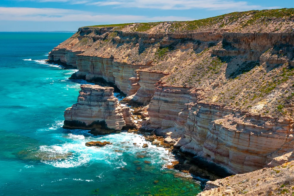
The Geological Phenomenon of Nambung National Park
Continuing north, the landscape transitions into the Swan Coastal Plain, home to the Pinnacles Desert within Nambung National Park. These limestone spires, some reaching four meters in height, are the remains of an ancient seabed, formed 25,000 to 30,000 years ago after the sea receded and left deposits of seashells. Over millennia, coastal winds removed the surrounding sand, revealing the pillars.
The Pinnacles hold deep cultural significance for the Yued people, who associate the landscape with the Wagyl, the rainbow serpent responsible for the creation of the region’s waterways and landforms. From a scientific perspective, the park represents a significant site for the study of aeolianite limestone. Management of the park involves maintaining the Pinnacles Desert Discovery Centre, which provides educational context on the flora and fauna of the region, including the Western Grey Kangaroo and various emu populations that frequent the scrubland.
Marine Conservation and Biodiversity in Jurien Bay
Further north lies Jurien Bay, a key site for marine conservation. The Jurien Bay Marine Park, established in 2003, protects a complex system of limestone reefs and seagrass meadows. These meadows are critical nurseries for the Western Rock Lobster and provide foraging grounds for the Australian sea lion (Neophoca cinerea), which is currently listed as "Endangered" under the Environment Protection and Biodiversity Conservation Act 1999.
The sea lion colonies at Buller Island and North Fisherman Island are among the few remaining breeding sites for the species. Access to these islands is strictly regulated by the Department of Biodiversity, Conservation and Attractions (DBCA) to ensure minimal human interference during breeding seasons. Tourism operators in Jurien Bay function under specific licenses that mandate distance requirements, reflecting a broader regional shift toward sustainable, non-consumptive wildlife tourism.
Maritime History and the Shipwrecks of Green Head
The coastal stretch near Green Head, specifically Dynamite Bay (known as Cuencandjaa to the Yued people), offers a stark reminder of the region’s colonial maritime history. The area gained notoriety in the 1960s when treasure hunters used explosives to recover artifacts from the Vergulde Draeck (Gilt Dragon), a Dutch East India Company (VOC) ship that foundered in 1656.
The Vergulde Draeck is one of several significant Dutch wrecks on the WA coast, including the Batavia and the Zuytdorp. These sites are now protected under the Underwater Cultural Heritage Act 2018. The discovery of silver coins and cargo from these vessels has provided historians with invaluable data regarding 17th-century trade routes and the early European presence in Australia.
Inland Exploration: Stockyard Gully and Regional Flora
The transition from coastal dunes to inland limestone ridges is best exemplified by Stockyard Gully National Park. The park features a 250-meter-long limestone tunnel formed by an ancient river system. This subterranean environment serves as a refuge for local wildlife during the extreme heat of the summer months.
The surrounding bushland is a focal point for the state’s wildflower industry. Western Australia boasts over 12,000 species of wildflowers, more than 60% of which are found nowhere else on Earth. The Mid-West region is particularly famous for the Wreath Flower (Lechenaultia macrantha) and various species of Banksia and Orchid. The blooming season, typically peaking between August and September, is a major driver of regional tourism, necessitating careful management of "wildflower wandering" to prevent the spread of Dieback (Phytophthora cinnamomi), a soil-borne water mould that threatens native vegetation.
Geraldton and the HMAS Sydney II Memorial
As the Indian Ocean Drive merges with the Brand Highway, travelers reach Geraldton, the regional capital of the Mid-West. Geraldton serves as a major port for grain, minerals, and livestock, but it is also a site of national mourning and remembrance. The HMAS Sydney II Memorial, situated on Mount Scott, commemorates the 645 crew members lost in November 1941 when the vessel was sunk by the German raider Kormoran during World War II.
The memorial, which features a silver dome made of 645 stainless steel gulls, serves as a "National Memorial of Significance." The discovery of the wreck in 2008, at a depth of roughly 2,500 meters, brought closure to one of Australia’s greatest maritime mysteries and reaffirmed Geraldton’s role as a guardian of naval history.
The Biochemistry of Hutt Lagoon
North of Geraldton, the landscape features the striking Hutt Lagoon, a salt lake famous for its pink hue. This coloration is a biological phenomenon caused by the presence of the carotenoid-producing algae Dunaliella salina. The lagoon is home to the world’s largest microalgae production plant, managed by BASF, where the algae are harvested for use as a source of Vitamin A, food coloring, and aquaculture feed. The intensity of the pink color fluctuates based on salinity levels, temperature, and light intensity, making it a subject of significant interest for both industrial chemistry and landscape photography.
Kalbarri: The Murchison River and the Skywalk Project
The journey culminates in Kalbarri, where the Murchison River meets the Indian Ocean. Kalbarri National Park, covering over 183,000 hectares, is characterized by dramatic red sandstone gorges and spectacular coastal cliffs. The park underwent a significant upgrade in 2020 with the opening of the Kalbarri Skywalk (Kaju Yatka). This $24 million project features two cantilevered walkways projecting 25 and 17 meters over the Murchison Gorge, providing views of the 400-million-year-old landscape.
The Murchison River is the second-longest river in Western Australia, and its gorge system offers a glimpse into the Tumblagoda Sandstone formations. These rocks contain "skolithos" (fossilized worm burrows), which are among the earliest evidence of land-based life in the region. The park’s management emphasizes a balance between high-adventurous recreation—such as hiking the 8-kilometer "Loop" trail—and the preservation of the delicate sandstone structures like Nature’s Window.
Economic and Environmental Implications
The continued development of the Indian Ocean Drive corridor reflects a strategic pivot by the Western Australian government toward diversifying the state’s economy. While mining and agriculture remain dominant, the investment in tourism infrastructure—such as the Kalbarri Skywalk and improved road safety—acknowledges the long-term value of the state’s natural assets.
However, this growth brings challenges. Local authorities and environmental groups have expressed the need for robust management to handle increased visitor numbers. Issues such as waste management in remote campsites, the protection of endangered sea lion habitats, and the mitigation of climate change impacts on wildflower blooming patterns are central to regional planning. The "Coral Coast" remains a primary example of how infrastructure can unlock economic potential while simultaneously placing a spotlight on the urgent need for environmental stewardship in one of the world’s most biodiverse regions.