The Hawaiian Islands are currently grappling with the aftermath of one of the most destructive weather events in recent history, as a pair of massive "Kona Low" storm systems stalled over the archipelago in mid-March 2026. The resulting deluge, which dropped upwards of four feet of rain on portions of Oʻahu and Maui, has triggered catastrophic flooding, displaced hundreds of residents, and necessitated a massive grassroots mobilization effort to clear debris and mud from inundated communities. Initial economic assessments from state officials and independent analysts suggest that the total cost of property damage and infrastructure repair could exceed $1 billion, marking the most expensive flooding event the state has witnessed in more than two decades.
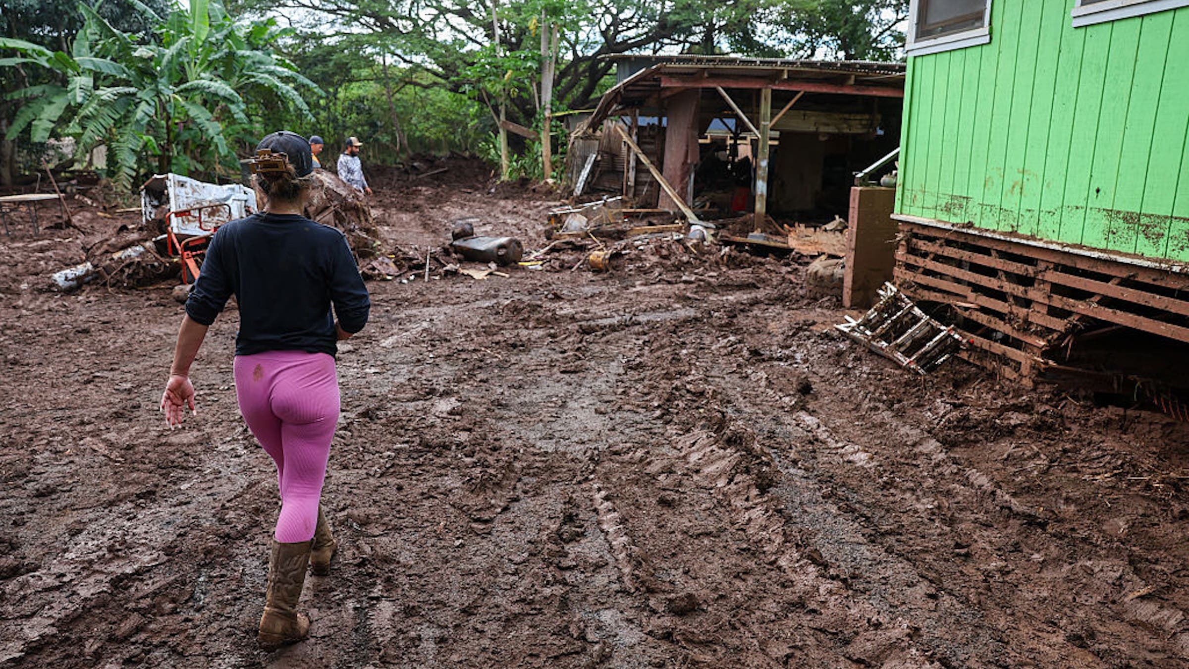
While the islands are accustomed to seasonal precipitation, the intensity and duration of this particular storm sequence caught many by surprise. According to data provided by the National Weather Service and corroborated by local reports, the storms saturated the ground so rapidly that traditional drainage systems were overwhelmed within hours. In the North Shore community of Waialua and the historic Otake Camp, the Kaukonahua Stream breached its banks, sending a torrent of water and sediment through residential streets, wedging vehicles under homes and depositing layers of thick, hazardous mud across the landscape.
Meteorological Context and the Mechanics of the Kona Low
To understand the scale of the current crisis, meteorologists point to the specific nature of the Kona Low. Unlike the typical trade-wind showers that characterize Hawaii’s weather, a Kona Low is a subtropical cyclone that develops in the central Pacific. These systems draw deep tropical moisture from the south—the "Kona" or leeward direction—and can remain stationary for several days.
In this instance, two distinct systems converged and sat over the islands starting around March 10, 2026. The first system saturated the volcanic soil, leaving no capacity for absorption when the second, more powerful cell arrived. By the time the skies began to clear in late March, some rain gauges on Oʻahu and Maui recorded nearly 48 inches of accumulation. This volume of water represents a significant percentage of the average annual rainfall for these regions, delivered in less than a two-week window. The sheer weight of the water led to landslides in the interior valleys and flash flooding in coastal plains, transforming quiet neighborhoods into disaster zones.
Chronology of the Crisis: From Saturation to Submersion
The timeline of the disaster reveals a rapidly escalating emergency that tested the limits of state and local response teams.
March 10–14, 2026: The initial storm system arrived, bringing steady, heavy rain. While initial warnings were issued for small craft and low-lying areas, the primary concern was localized ponding. However, by March 14, the ground reached a point of total saturation.
March 15–19, 2026: The second Kona Low system intensified. Flash flood emergencies were declared across Maui and Oʻahu. During this period, more than 230 individuals were rescued by emergency personnel, including several dramatic airlifts from the North Shore where roads had become impassable. Miraculously, despite the destruction of property, no fatalities have been officially reported to date.
March 20–22, 2026: As the rain began to taper off, the true extent of the damage became visible. In Waialua, residents emerged to find their community buried under "fudge-like" mud. It was during this window that the grassroots "Lāhui Foundation" and local organizers, including Esme Damon and Brie Thomson, established a command center at the Haleiwa Distilling Company and the Waialua Sugar Mill.
March 23–24, 2026: The transition from active rescue to recovery began in earnest. Thousands of volunteers from across the island converged on the North Shore, organized largely through real-time updates on social media platforms like Instagram.
The Human Toll and Community Response
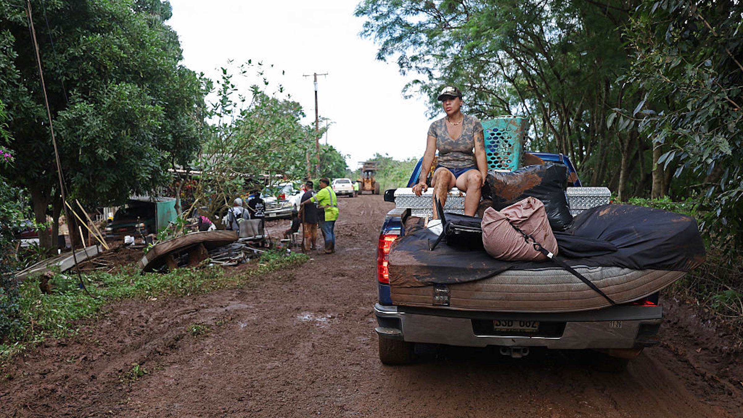
The visceral reality of the disaster is perhaps most evident in Otake Camp, a close-knit community situated near the Kaukonahua Stream. The flooding here was not merely a matter of rising water; it was an influx of mud, septic overflow, and agricultural runoff. Residents and volunteers have been forced to wear face masks to mitigate the pungent odor of mildew and waste as they shovel heavy sediment out of living rooms and kitchens.
Witness accounts describe an "assembly line" of volunteers working in tandem with heavy machinery to clear thoroughfares. The Waialua Sugar Mill has become a logistical hub, where a constant stream of vehicles delivers donated supplies—brooms, squeegees, trash bags, and food—while others depart to distribute these items to families who remain trapped by debris or lack of transportation. Representative Sean Quinlan noted that on a single Sunday, thousands of people arrived at the mill to offer aid, reflecting a profound sense of community resilience, often referred to in the islands as the "Alu Like" spirit—working together to achieve a common goal.
The destruction extends beyond residential property. On Waialua Beach Road, a primary artery for the region, the force of the water was strong enough to wash entire structures against bridges and erode sidewalks completely. The sight of cars wedged in improbable positions serves as a stark reminder of the hydraulic power unleashed by the storm.
Economic Impact and Infrastructure Analysis
The $1 billion damage estimate is a preliminary figure that accounts for private property loss, agricultural destruction, and the massive cost of public infrastructure repair. Hawaii’s Department of Transportation is currently assessing the integrity of bridges and roadways that were submerged for days. The long-term impact on the agricultural sector is also a point of concern; the North Shore is home to numerous small farms that have seen their crops ruined and their topsoil washed away by the runoff.
Furthermore, the tourism industry—a pillar of the Hawaiian economy—is facing immediate disruption. The North Shore, famous for its winter surf and scenic coastline, is currently in no position to host visitors. Officials have taken the unusual step of asking tourists to rethink their travel plans, urging them to avoid the North Shore entirely to allow recovery crews unhindered access to the roads. The diversion of tourism revenue, coupled with the high cost of reconstruction, poses a significant challenge to the state’s fiscal health for the remainder of 2026.
Broader Implications and Environmental Analysis
Environmental scientists and urban planners are viewing the March 2026 floods as a clarion call for improved disaster preparedness and climate adaptation. The fact that this is the worst flooding in 20 years suggests that the "once-in-a-generation" storm is becoming a more frequent occurrence. Analysts point to several factors that exacerbated the crisis:
- Urban Runoff: As more land is developed, there are fewer permeable surfaces to absorb rainwater, leading to higher volumes of runoff during extreme events.
- Stream Maintenance: The clogging of natural waterways with invasive vegetation and debris contributed to the breaching of banks in areas like Otake Camp.
- Climate Trends: Rising sea levels and warmer ocean temperatures are providing more "fuel" for storms like the Kona Low, increasing their precipitation potential.
The recovery process is expected to take months, if not years. While the immediate focus remains on clearing mud and restoring basic services, the state legislature is already facing calls to invest in more robust flood mitigation infrastructure, such as improved levee systems and larger-capacity drainage networks.
Official Guidance for Aid and Recovery
State officials and community leaders are emphasizing that while the surge of volunteerism is welcomed, it must be coordinated to be effective. Grassroots organizations have established digital portals, such as the Oʻahu Flood Relief and the Lāhui Foundation Post-Flood Recovery forms, to match volunteers with specific needs.
For those looking to assist from afar, monetary donations to established local non-profits are being cited as the most efficient way to provide relief. These funds are being used to purchase professional-grade cleaning equipment, mold remediation supplies, and essential household goods for those who have lost everything.
As the islands dry out, the focus shifts to the long-term stability of the affected communities. The March 2026 Kona Low will likely be remembered not just for the record-breaking rainfall, but for the unprecedented scale of the community-led response that followed in its wake. The road to recovery for Oʻahu and Maui is long, but the mobilization at the Waialua Sugar Mill stands as a testament to the state’s collective resolve in the face of natural disaster.