The Mary River Wetlands, located approximately 150 kilometers east of Darwin, represent one of the most significant ecological corridors in Australia’s Northern Territory, serving as a critical sanctuary for the world’s highest concentration of estuarine crocodiles and a diverse array of avian species. While the Northern Territory’s capital is often associated with the high-adrenaline "jumping crocodile" cruises of the Adelaide River, the Mary River system offers a more expansive and primitive encounter with the Top End’s wild interior. This vast landscape, characterized by lily-fringed lagoons, verdant floodplains, and dense monsoon forests, provides a complex network of habitats that sustain both local biodiversity and a burgeoning eco-tourism industry.
The Ecological Significance of the Mary River Catchment
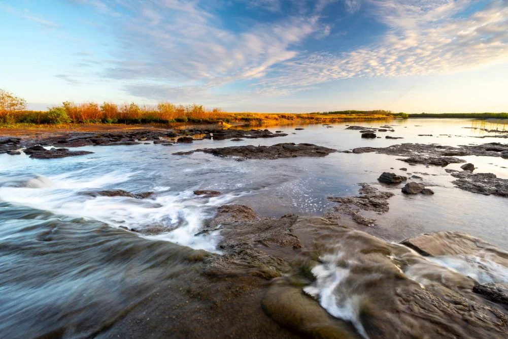
The Mary River National Park protects a substantial portion of the Mary River catchment, an area that has undergone significant environmental management over the last four decades. Unlike many other river systems in the Top End, the Mary River does not have a single main channel that reaches the sea; instead, it diffuses into a series of vast, interconnected wetlands and billabongs. This unique geography creates a highly productive environment for flora and fauna but also leaves the freshwater systems vulnerable to saltwater intrusion.
In the late 1980s, environmental authorities and engineers constructed a skinny concrete barrage across the river at Shady Camp. The primary objective was to safeguard the upstream freshwater habitats from the encroaching tidal salt water of the Arafura Sea. This intervention was deemed necessary after decades of damage caused by feral water buffalo, whose heavy movement had created swim-ways that allowed salt water to penetrate deep into the freshwater marshes, killing off large tracts of paperbark forests. Today, the barrage serves as a literal and figurative line in the sand, separating the tidal reaches from the freshwater sanctuary, though it remains a porous barrier for the region’s most famous inhabitants: the saltwater crocodiles (Crocodylus porosus).
A Chronology of Exploration: From Stuart to the Modern Era
The human history of the Mary River is as storied as its natural history. The region gained colonial prominence during the mid-19th century as explorers sought a route from the south of the continent to the northern coast.
- 1862: Explorer John McDouall Stuart, leading his sixth expedition, reached the banks of the Mary River. He named the site "Shady Camp" after finding respite under the dense canopy of the riverside vegetation. Stuart eventually reached the Arafura Sea at Chambers Bay, marking the first successful south-to-north crossing of the Australian continent. This feat opened the "mysterious interior" to future telegraph lines and pastoral development.
- Late 19th – Early 20th Century: The region was utilized for pastoral leases, primarily for cattle and buffalo. However, the seasonal flooding made permanent settlement difficult.
- 1960s – 1980s: Rising awareness of the environmental degradation caused by feral buffalo led to the implementation of the Brucellosis and Tuberculosis Eradication Campaign (BTEC), which significantly reduced buffalo numbers and allowed the wetlands to begin a slow recovery.
- 1990s – Present: The establishment and expansion of the Mary River National Park shifted the focus toward conservation and sustainable tourism. The area is now managed under strict environmental protocols to balance the needs of recreational anglers with the preservation of the delicate wetland ecosystem.
The "Run-Off" Phenomenon and the Angling Economy
The Mary River is internationally renowned as a premier destination for barramundi (Lates calcarifer) fishing. This reputation is largely driven by the "run-off"—the period at the end of the wet season (typically March to May) when the floodwaters from the plains drain back into the river channels.
As the water recedes, it carries a wealth of nutrients and small baitfish over the Shady Camp barrage. This creates a feeding frenzy for larger predators. Anglers from across the globe congregate at the barrage to cast lines for trophy-sized barramundi, often standing in close proximity to estuarine crocodiles. According to Northern Territory Department of Industry, Tourism and Trade data, recreational fishing contributes over $270 million annually to the NT economy, with the Mary River being a primary contributor to this figure.
However, the intersection of human activity and apex predators necessitates a rigorous "Be Crocwise" safety campaign. The Northern Territory government emphasizes that in the Mary River system, crocodiles are always present, even if not visible. The proximity of anglers to these predators at Shady Camp remains a point of concern for safety officials, who advocate for fishing from elevated platforms or boats rather than the water’s edge.
Biodiversity and Avian Habitats
Beyond the reptilian and aquatic life, the Mary River Wetlands are a critical site for migratory and resident birds. The region is part of the Adelaide and Mary River Floodplains Important Bird Area (IBA).
Key Species and Observations
- Comb-crested Jacanas: Often called "Jesus birds" for their ability to walk on floating lily pads, these birds thrive in the freshwater lagoons of the Mary River.
- Magpie Geese: During the dry season, tens of thousands of magpie geese congregate in the wetlands to feed on the bulbs of water chestnuts.
- Jabiru (Black-necked Stork): Australia’s only stork species is a frequent sight in the shallows of Mistake Billabong and Rockhole.
- Predatory Birds: The abundance of fish supports high populations of White-bellied Sea Eagles and Whistling Kites.
The Jimmy Creek and Brian Creek Monsoon Forest Walks offer a different perspective of the park’s biodiversity. These pockets of dense vegetation provide a microclimate that supports orange-footed scrub fowls, which build massive incubation mounds on the forest floor, and various species of fruit bats and flying foxes.
Infrastructure and Tourism Management
To manage the influx of visitors while minimizing environmental impact, the Northern Territory Parks and Wildlife Commission has developed specific infrastructure at key locations:
- Shady Camp: Serving as the primary hub for anglers, it offers boat ramps and basic camping facilities. It is the site of the historical crossing and the salt-to-freshwater barrage.
- Couzens Lookout: This site provides a more tranquil camping experience. Its elevated position offers panoramic views of the billabongs and is a preferred spot for sunset viewing. The campground is equipped with wheelchair-accessible facilities, reflecting a move toward inclusive tourism.
- Point Stuart Wilderness Lodge: This private enterprise complements the national park’s offerings, providing higher-end accommodation, guided safaris, and boat rentals. Such partnerships are vital for the region’s tourism infrastructure, allowing for a range of visitor experiences from rustic camping to catered tours.
Environmental Challenges and Future Outlook
While the Mary River Wetlands are currently a thriving ecosystem, they face several long-term threats that require ongoing management and scientific oversight.
Salinity and Sea-Level Rise
Despite the success of the Shady Camp barrage, the long-term threat of sea-level rise remains. Climate modeling suggests that increased tidal heights could eventually overtop current barriers, leading to widespread saltwater intrusion that would transform the freshwater wetlands back into salt marshes, significantly altering the current biodiversity.
Invasive Species
While buffalo numbers are managed, other invasive species like the Mimosa pigra (a woody weed) and feral pigs continue to pose threats to the native vegetation and soil stability. The NT government invests significant resources into weed management and feral animal control to maintain the integrity of the floodplains.
Sustainable Tourism
The balance between promoting the Mary River as a "fishing Mecca" and preserving its "primitive" appeal is delicate. Park officials monitor visitor numbers and environmental health to ensure that the "secret" of the Mary River is not lost to over-commercialization.
Conclusion and Visitor Logistics
The Mary River Wetlands stand as a testament to the resilience of the Top End’s natural systems. For those traveling from Darwin, the transition from the modern waterfront to the ancient, predator-rich marshes of the Mary River takes only a few hours but offers a profound shift in perspective.
For prospective visitors, the dry season (May to September) remains the optimal window for exploration. During this time, temperatures range from 20°C to 31°C, and the receding waters make the park accessible to conventional vehicles. The Northern Territory government requires a park pass for entry, with funds reinvested into the maintenance and conservation of the site. Whether for the pursuit of the elusive "metery" barramundi or the silent observation of a Jabiru in the morning mist, the Mary River Wetlands remain one of Australia’s most vital and evocative wilderness areas.