 Walid Sujud Trenggono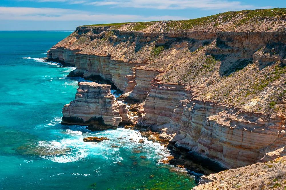
The Indian Ocean Drive, a 270-kilometer stretch of fully sealed roadway connecting Yanchep to Dongara, has emerged as one of Australia’s most significant scenic corridors, providing a critical link between the metropolitan sprawl of Perth and the diverse ecosystems of the state’s mid-west. For travelers extending their journey to Kalbarri, the route covers approximately 600 kilometers, traversing a landscape defined by dramatic limestone formations, ancient marine life, and a seasonal wildflower bloom that is recognized as one of the most spectacular botanical displays on Earth. This corridor not only serves as a vital artery for regional tourism, which contributes significantly to Western Australia’s economy, but also acts as a gateway to the Coral Coast, a region where the arid desert meets the temperate waters of the Indian Ocean.
Geological Heritage and the Gateway to the North
The journey north of Perth begins in the coastal town of Lancelin, known natively to the Yued people as Wangaree. This region serves as a primary example of the shifting geomorphology of the Swan Coastal Plain. The Lancelin sand dunes, which rise to significant heights on the town’s northern periphery, are part of a mobile dune system that continues to drift toward the sea. These dunes are not merely recreational hubs for sandboarding and off-road vehicles; they are geological indicators of the prevailing southerly winds and the historical movement of coastal sediments.
Offshore, the Lancelin Island Nature Reserve provides a sanctuary for a complex ecosystem. The surrounding reef system is the site of 14 documented shipwrecks, a testament to the treacherous maritime history of the West Australian coast. These reefs are essential nurseries for the Western Rock Lobster (Panulirus cygnus), an industry that remains a cornerstone of the regional economy. According to data from the Western Rock Lobster Council, this fishery was the first in the world to be certified as sustainable by the Marine Stewardship Council (MSC), a status it has maintained for over two decades.
The Pinnacles and the Yued Cultural Landscape
Further north, within the 17,487-hectare Nambung National Park, lies the Pinnacles Desert. These thousands of limestone spires, some reaching heights of four meters, were formed approximately 25,000 to 30,000 years ago after the sea receded and left deposits of seashells. Over millennia, coastal winds removed the surrounding sand, exposing the pillars. While early European explorers in the 17th century initially mistook the formations for the ruins of a lost city, the site holds deep spiritual significance for the Yued people.
In Indigenous folklore, the landscape is tied to the Wagyl, a rainbow serpent deity responsible for the creation of the region’s waterways and landforms. Tourism Western Australia reports that Nambung National Park receives hundreds of thousands of visitors annually, making it one of the most visited natural attractions in the state. To manage this influx, the Department of Biodiversity, Conservation and Attractions (DBCA) has implemented a loop drive and designated walking trails to minimize the impact on the fragile desert pavement and the resident fauna, which includes western grey kangaroos and a variety of reptile species.
Marine Conservation and Biodiversity in Jurien Bay
The town of Jurien Bay represents a critical node for marine conservation. The Jurien Bay Marine Park, established in 2003, protects a unique temperate-tropical overlap zone. This area is home to one of the few breeding colonies of the Australian sea lion (Neophoca cinerea), one of the rarest seal species in the world. With an estimated total population of fewer than 12,000 individuals, the colonies at Buller Island, North Fisherman Island, and Essex Rocks are strictly monitored.
Commercial tour operators in the region operate under stringent environmental guidelines to ensure that human interaction does not disrupt the breeding cycles of these pinnipeds. Beyond the sea lions, the marine park protects extensive seagrass meadows that serve as carbon sinks and provide habitat for a diverse array of marine life, including dolphins and migrating humpback whales, which pass through these waters between July and October.
The coastal town of Green Head, located north of Jurien Bay, offers further historical and geological depth. Dynamite Bay, a natural amphitheater of turquoise water, derives its name from 1960s-era treasure hunters who used explosives to search for the wreckage of the Vergulde Draeck (Gilt Dragon). This Dutch East India Company ship sank in 1656, carrying a substantial cargo of silver coins. The maritime history of this "Shipwreck Coast" is a primary driver for heritage tourism in the region.
Subterranean Exploration and Botanical Diversity
Inland from the coast, the Stockyard Gully Caves offer a glimpse into the region’s karst topography. The 250-meter-long limestone tunnel was once part of a stock route for drovers moving cattle between Geraldton and Perth. Today, it is managed as a reserve, showcasing the results of ancient river systems that carved through the limestone.
The vegetation surrounding Stockyard Gully is part of the Southwest Australian Biodiversity Hotspot. During the peak months of July through October, the region is transformed by the bloom of over 12,000 wildflower species, many of which are endemic to Western Australia. Data from the Western Australian Herbarium indicates that the state’s wildflower season is a significant economic driver, attracting international botanical enthusiasts and researchers. Key species include the wreath flower (Lechenaultia macrantha), various species of Banksia, and the Queen of Sheba orchid.
Maritime Tragedy and Scientific Phenomena in Geraldton
As the Indian Ocean Drive merges with the Brand Highway, the city of Geraldton serves as the regional hub for the Mid West. Geraldton’s history is inextricably linked to the sea, a fact underscored by the HMAS Sydney II Memorial. This site commemorates the 645 sailors lost in 1941 during a World War II battle with the German raider HSK Kormoran. The discovery of the wreck in 2008, at a depth of 2,500 meters, provided closure to a decades-long mystery and remains a point of national significance.
North of Geraldton, the landscape features the leaning trees of Greenough—river gums (Eucalyptus camaldulensis) that have grown horizontally in response to the persistent and powerful salt-laden winds from the Indian Ocean. This area also leads to Hutt Lagoon, a 70-square-kilometer salt lake known for its vibrant pink hue.
The coloration of Hutt Lagoon is a result of the presence of the carotenoid-producing algae Dunaliella salina. This microalga is commercially harvested by BASF, which operates one of the world’s largest microalgae production plants on the lake’s shores. The beta-carotene extracted from the lake is used globally as a source of Vitamin A and as a natural food coloring. The lake’s intensity varies according to the season and time of day, creating a significant visual landmark for the region.
Kalbarri and the Murchison River System
The northern terminus of this coastal journey is Kalbarri, a town situated at the mouth of the Murchison River. The landscape here is dominated by the Kalbarri National Park, which covers 186,000 hectares and features red sandstone gorges carved by the river over 400 million years.
In 2020, the Western Australian government completed the Kalbarri Skywalk, a $24 million infrastructure project consisting of two cantilevered walkways that project 25 and 17 meters over the Murchison Gorge. This project was designed to boost regional tourism following the impact of Cyclone Seroja in 2021. The Skywalk offers views of the Tumblagooda Sandstone, which contains fossilized trackways of Eurypterids (giant sea scorpions), some of the earliest evidence of land-dwelling animals.
The Murchison River itself provides a stable environment for recreation and local fisheries. The sandbar at the river’s mouth creates a protected estuary, though the "Zuytdorp Cliffs" to the north remain some of the most rugged and dangerous coastline in Australia. The town’s economy is a blend of tourism and professional fishing, with local establishments like Finlays Kalbarri emphasizing the "sea-to-table" movement, utilizing the abundant seafood of the Gascoyne and Mid West regions.
Analysis of Economic and Environmental Implications
The development and promotion of the Indian Ocean Drive have fundamentally altered the economic landscape of Western Australia’s central coast. Historically, these coastal towns were isolated fishing outposts. The sealing of the road in 2010 facilitated a shift toward high-volume tourism. However, this growth brings challenges regarding environmental management.
The DBCA and local shires face the ongoing task of balancing visitor numbers with the preservation of fragile dune systems and the protection of endangered species like the Australian sea lion. Furthermore, the region is on the frontline of climate change, with rising sea levels and increased storm intensity threatening coastal infrastructure.
From a journalistic perspective, the Indian Ocean Drive represents more than a scenic route; it is a case study in how infrastructure can drive regional development while necessitating a sophisticated approach to conservation. The integration of Indigenous heritage, scientific industry (such as the algae harvesting at Hutt Lagoon), and historical preservation ensures that the corridor remains a vital component of Western Australia’s identity. As regional travel continues to evolve, the Indian Ocean Drive will likely remain a primary focus for both state investment and international interest, standing as a testament to the enduring allure of the Australian wilderness.



 Anjar Salim
 Chandra Hamzah
 Tatiana Tantri Indah Sari
 Budi Mulyono