
 Anjar Salim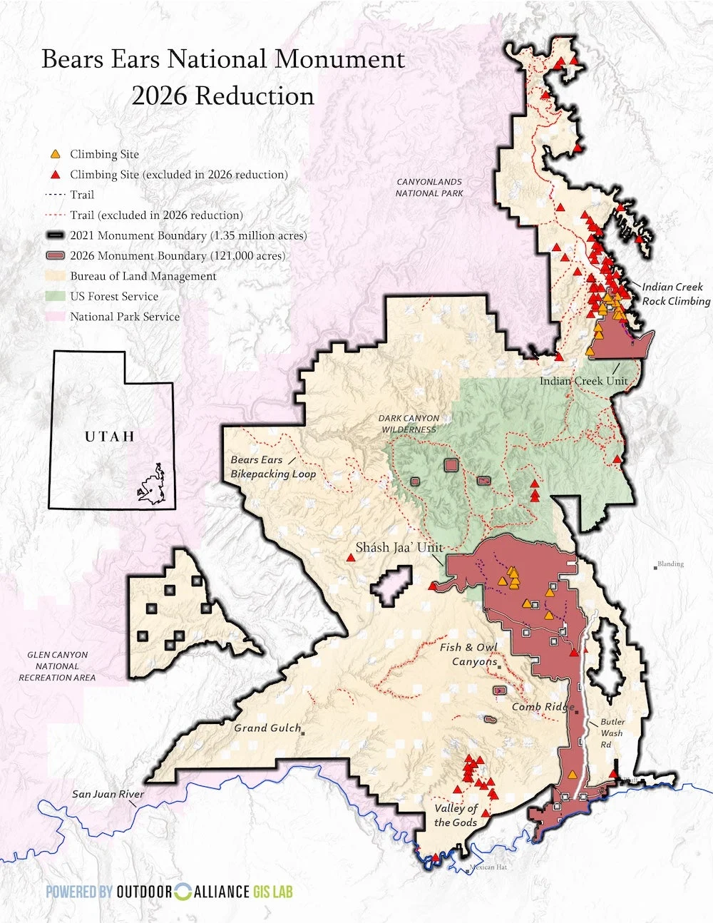
The landscape of southeastern Utah is undergoing a rapid and controversial transformation as federal workers begin the physical removal of Tribal insignia and boundary markers from the Bears Ears National Monument. This administrative action follows a July 13, 2026, presidential proclamation that drastically reduced the protected area by nearly 90 percent, a move that has reignited a fierce national debate over land sovereignty, conservation, and the limits of executive power. As the Bureau of Land Management (BLM) executes orders to dismantle the monument’s infrastructure, Tribal leaders and conservationists are warning that the removal of these symbols represents a deeper erasure of Indigenous history and a collapse of hard-won federal-Tribal partnerships.
The most visible sign of this shift occurred near the gateway communities of Bluff and Mexican Hat, where five Tribal seals—representing the Hopi Tribe, Navajo Nation, Pueblo of Zuni, Ute Mountain Ute Tribe, and Ute Indian Tribe—were stripped from the official entrance signage. These seals were not merely decorative; they served as the physical manifestation of the Bears Ears Commission, a historic co-management body established to ensure that Indigenous traditional ecological knowledge would guide the stewardship of the land. With the commission now formally dissolved by executive order, the federal government has moved to rebrand the landscape, signaling a return to unilateral federal control.
A Chronology of Monument Volatility
The current crisis at Bears Ears is the latest chapter in a decade-long political and legal tug-of-war. To understand the gravity of the July 2026 reductions, one must look at the unprecedented fluctuations in the monument’s boundaries over the last ten years.
In December 2016, President Barack Obama designated 1.35 million acres as the Bears Ears National Monument, responding to a historic proposal from a coalition of five sovereign Tribal nations. This was the first time in American history that a national monument was created at the specific request of Native American tribes with a mandate for collaborative management.
However, the designation was short-lived. In December 2017, during his first term, President Donald Trump signed a proclamation reducing the monument by 85 percent, splitting the remaining land into two non-contiguous units: Shash Jáa and Indian Creek. This reduction stood until October 2021, when President Joe Biden issued a proclamation restoring the original boundaries and slightly expanding the monument to 1.36 million acres, while also re-establishing the Inter-Tribal Commission.
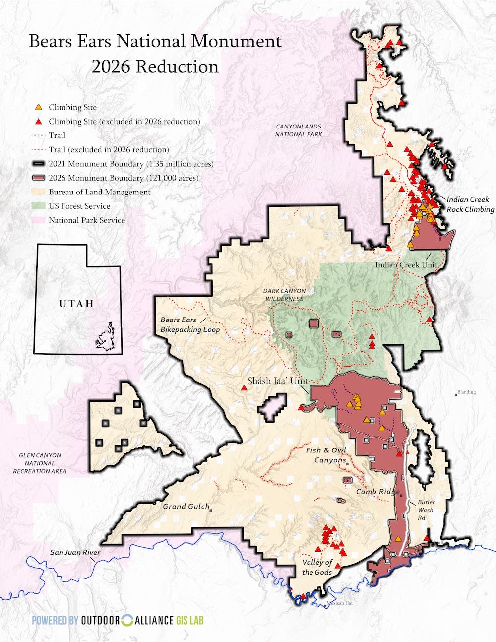
The July 13, 2026, proclamation represents the most severe cut to date. By reducing Bears Ears to approximately 121,000 acres, the current administration has left protected only a small fraction of the archaeological and cultural sites originally included. Concurrently, the neighboring Grand Staircase-Escalante National Monument was reduced from 1.9 million acres to roughly 182,000 acres. Together, these actions removed federal monument protection from nearly 3 million acres of public land in Utah in a single day.
The Dissolution of the Inter-Tribal Commission
The removal of the Tribal seals is the direct result of the administration’s decision to terminate the Bears Ears Commission. The commission was designed to provide a formal structure for Tribal nations to provide guidance on the management of sacred sites, herb gathering, and the protection of ancestral remains.
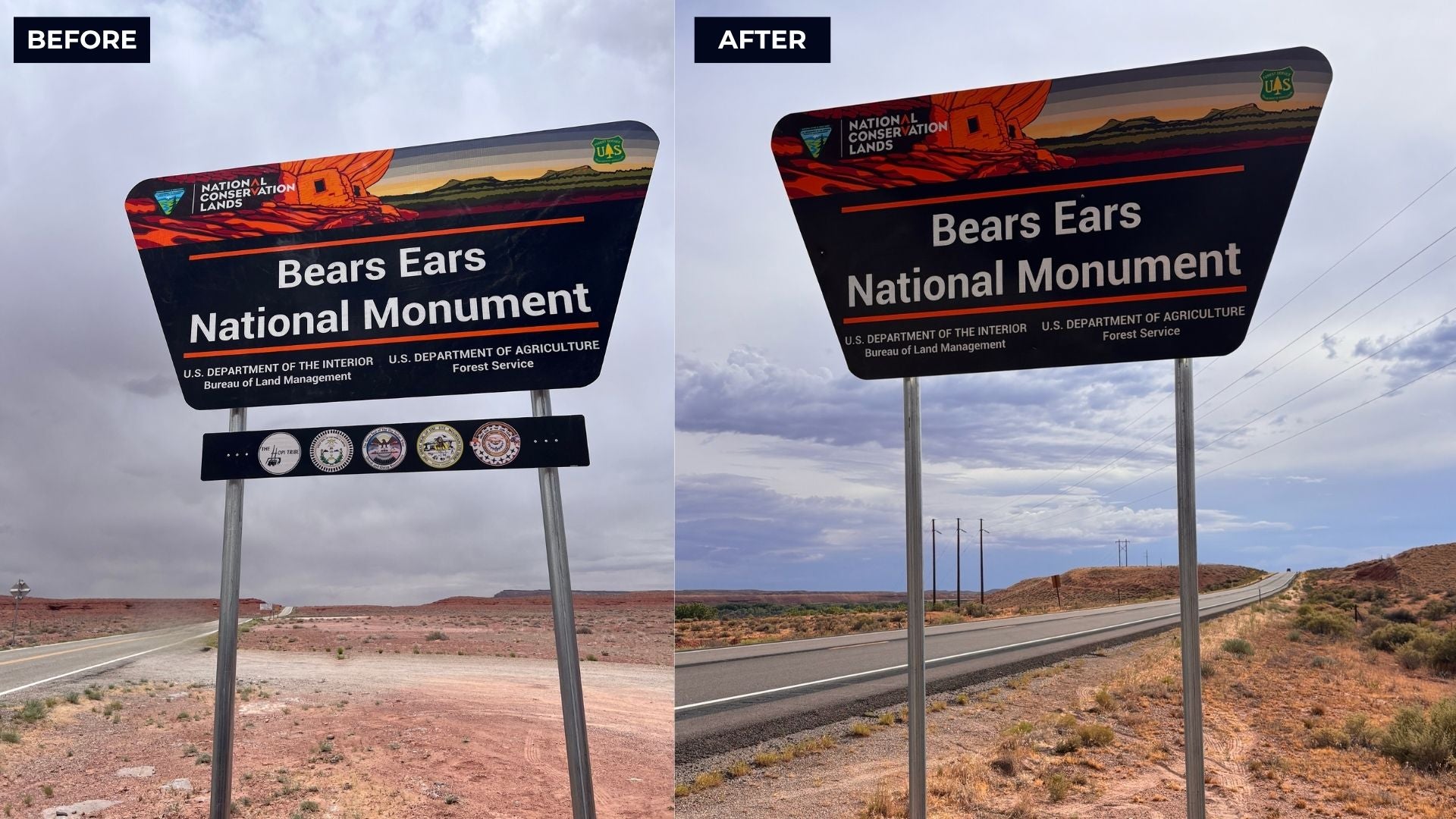
A spokesperson for the BLM confirmed that the removal of the seals is a matter of administrative consistency. "The BLM has begun efforts to implement the modified boundaries of Bears Ears National Monument established by President Trump on July 13, 2026," the spokesperson stated. "The seals were a recognition of the Bears Ears Commission, which has been disbanded and terminated. The BLM will continue to consult with tribal nations in accordance with applicable laws, but the formal commission structure no longer exists."
For Tribal representatives, the logic of "administrative consistency" feels like a betrayal of trust. Davina Smith-Idjesa, a representative of the Navajo Nation and co-chair of the Bears Ears Inter-Tribal Coalition, expressed the emotional and cultural toll of the removal. "When I first saw that the Bears Ears signs and Tribal seals had been removed, I just sat there with a lump in my throat," she said. "Native people have seen promises broken, treaties ignored, and lands taken when they held something others wanted. It made me wonder whether we are watching another version of that happen today."
Quantifying the Loss: Archaeological and Recreational Data
The impact of the 2026 boundary shifts extends beyond symbolism. According to data compiled by The Wilderness Society and the Outdoor Alliance, the new boundaries exclude thousands of significant sites and miles of recreational infrastructure.
In Bears Ears, the revised map now excludes more than 500 miles of established trails and over 1,200 climbing routes and boulder problems. Many of these areas, such as the world-renowned climbing walls of Indian Creek, are now subject to different management priorities, which could include renewed interest in mineral extraction or expanded grazing permits.
From an archaeological perspective, the losses are even more staggering. The Bears Ears region is estimated to contain more than 100,000 cultural sites, including cliff dwellings, granaries, and extensive rock art panels. By shrinking the monument to 121,000 acres, the vast majority of these sites are no longer covered by the heightened protections and specialized funding associated with a National Monument designation. While they remain on federal land, they are now managed under the BLM’s "multiple-use" mandate, which critics argue provides insufficient protection against looting, vandalism, and industrial development.
At Grand Staircase-Escalante, the exclusion of 230 miles of trails and 100 climbing routes further highlights the scale of the reduction. This monument, famous for its unique paleontology, has yielded dozens of new dinosaur species over the last two decades. Paleontologists have expressed concern that the reduction in size will lead to a decrease in the federal resources available for fossil preservation and research.
Political and Economic Justifications
The administration has justified these reductions by citing the Antiquities Act of 1906, which grants presidents the authority to protect "objects of historic or scientific interest" but specifies that the reservations must be limited to the "smallest area compatible with the proper care and management of the objects to be protected."
Proponents of the reduction, including many local officials in San Juan and Kane Counties, argue that the original designations were "monumental land grabs" that stifled local economies and restricted traditional land uses like ranching and mining. They contend that the 2026 boundaries focus protections on the most critical sites while allowing the rest of the land to be utilized for economic growth.
However, economic data from the last decade suggests a more complex reality. The outdoor recreation economy in Utah has seen explosive growth, with gateway communities near the monuments benefiting from increased tourism. Organizations like the Outdoor Alliance argue that shrinking the monuments creates "management chaos" that threatens the stability of the local tourism industry.
"Shrinking these monuments by more than ninety percent doesn’t just erase lines on a map," said Adam Cramer, CEO of Outdoor Alliance. "It also attempts to erase the vision of the five tribal nations to protect their ancestral homeland in a generous and inclusive way for the benefit of all Americans."
Legal Challenges and Future Implications
The removal of the signs and the reduction of the boundaries are almost certain to face immediate legal challenges. Following the 2017 reductions, a coalition of Tribes and environmental groups sued the federal government, arguing that the Antiquities Act allows a president to create a monument but does not grant the power to abolish or significantly diminish one. That legal question was never fully resolved by the Supreme Court because the Biden administration restored the boundaries before a final ruling could be reached.
Legal experts suggest that the 2026 proclamation will force the judiciary to finally settle this constitutional question. If the courts uphold the president’s right to shrink monuments, it could set a precedent that makes every national monument subject to the political whims of whoever occupies the White House, potentially ending the era of permanent land conservation under the Antiquities Act.
For the Tribes of the Bears Ears Coalition, the fight is not just about legal precedents or recreational access; it is about the recognition of their continued existence on the land. Ruben Pacheco, communications and partnerships director for the coalition, noted that community members began reporting the removal of the signs on July 20, 2026. "Based on what we’re seeing, the seals are being removed from signs within the new boundaries, and the signs outside the new boundaries are being removed completely," he said.
Despite the physical removal of their emblems, Tribal leaders insist their connection to the land remains unbreakable. "Removing the signs does not erase our relationship to Bears Ears," Smith-Idjesa concluded. "The Coalition Tribes will continue to carry that responsibility, no matter what signs are standing on the side of the road. Those signs represented hope, but our history is longer than any administration’s term."
As the BLM continues its work in the Utah desert, the empty frames of the monument signs stand as a stark reminder of the shifting tides of American land policy. The 2026 reduction of Bears Ears and Grand Staircase-Escalante has not only redrawn the maps of the West but has also reopened deep wounds in the relationship between the federal government and the sovereign nations who have called this landscape home for millennia.



 Chandra Hamzah
 Tatiana Tantri Indah Sari
 Budi Mulyono
 Lukman Taruna Persada Ramadan