Tasmania’s reputation as a premier destination for nature-based tourism has been further solidified by the growing popularity of the Bay of Fires, a region recently distinguished as Australia’s most beautiful beach for 2025. Located on the island’s northeastern coast, the area—known traditionally as Larapuna—offers a blend of rugged geological formations, rich Indigenous history, and diverse ecosystems. Recent data from Tourism Tasmania indicates a significant uptick in "soft adventure" tourism, where travelers seek immersive wilderness experiences without sacrificing modern comforts. Intrepid Travel’s three-day guided trek through the Bay of Fires exemplifies this trend, providing a structured exploration of the Humbug Point Conservation Area and Mount William National Park.
The Geographic and Historical Significance of Larapuna
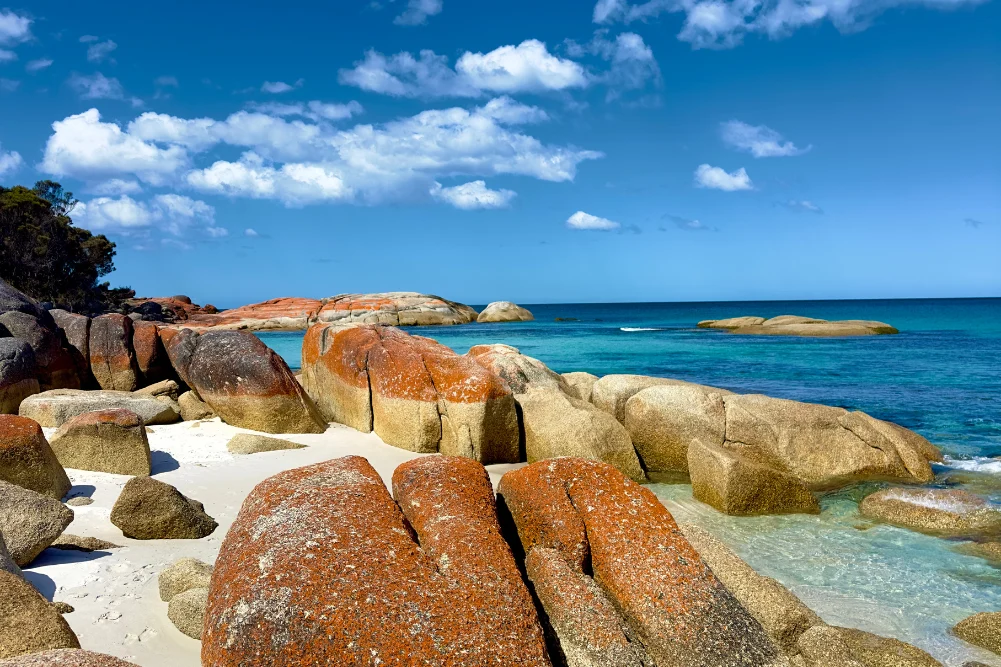
The Bay of Fires encompasses a stretch of coastline from Binalong Bay in the south to Eddystone Point in the north. The region’s name is often misinterpreted as a reference to the orange lichen that coats the granite boulders; however, its origins date back to 1773. Captain Tobias Furneaux, navigating the HMS Adventure, observed numerous fires along the coast. These fires were the traditional land management practices and campfires of the Palawa people, the Aboriginal Tasmanians who have inhabited the region for millennia. Today, the name serves as a dual reminder of the area’s cultural heritage and its striking visual palette.
The distinctive orange hue found on the granite rocks is caused by a type of crustose lichen from the family Teloschistaceae. This biological phenomenon, combined with the high quartz content of the white sand and the clarity of the Tasman Sea, creates a high-contrast landscape that has become a focal point for international photography and conservation efforts. The region’s geology is predominantly Devonian granite, which has been sculpted by maritime erosion over millions of years into the "cairn-like" arrangements and "Picasso-esque" boulders that define the coastline.
Chronology of the Three-Day Guided Expedition
The Intrepid Travel itinerary is designed as a progressive physical challenge, beginning with introductory coastal walks and culminating in longer treks through diverse terrains.
Day One: The Humbug Point Conservation Area
The expedition commences in Launceston, Tasmania’s second-largest city, before transitioning to St Helens, the administrative and commercial hub of the northeast. The initial phase of the trek focuses on the Skeleton Bay Track, leading toward Dora Point within the Humbug Point Conservation Area. This segment is characterized by coastal heathland and "sneaky rain"—a local colloquialism for the high-humidity precipitation common to the Roaring Forties latitudes.
The flora in this region is a complex mix of flowering paperbarks, banksia, tea trees, and various eucalyptus species. For hikers, this serves as an introduction to the "bulldozer of the bush"—the common wombat (Vombatus ursinus). While the animals are nocturnal and often elusive during daylight hours, their presence is marked by distinctive cubic droppings, a biological adaptation that prevents the scat from rolling off the uneven granite surfaces they use to mark territory.
Day Two: Eddystone Point and the Granite Coast
The second day represents the trek’s most demanding segment, covering approximately 12 kilometers and an average of 25,000 steps. The journey moves north to Eddystone Point (Larapuna), home to a 35-meter-high lighthouse constructed in 1889 from local pink granite. This site is a critical maritime landmark, situated at a point where the Bass Strait meets the Tasman Sea, an area historically prone to "nautical carnage" due to high winds and submerged reefs.
The 6-kilometer walk along Eddystone Beach exposes hikers to the raw power of the Southern Ocean. The environment here is a sanctuary for avian species, including Pacific gulls, sandpipers, and oystercatchers. The latter are known for their high-pitched, "squeaky toy" calls and their role as indicators of a healthy intertidal ecosystem. The beach is also a repository for "Neptune’s necklace" (Hormosira banksii), a brown algae that forms intricate patterns along the shoreline.
Day Three: Mount William National Park and the Interior
The final day focuses on Mount William National Park, a vital refuge for the Forester kangaroo and the Tasmanian devil. The trek includes a 6-kilometer loop at Stumpy’s Bay, where the landscape shifts from sandy dunes to chunky rock formations. The day concludes with a transition back toward Launceston, featuring stops at Little Blue Lake and the historic town of Derby.
Environmental and Biological Analysis
Tasmania’s isolation from mainland Australia has resulted in a unique evolutionary trajectory for its wildlife. The short-beaked echidna (Tachyglossus aculeatus) found in the Bay of Fires is notably larger and possesses thicker fur than its mainland counterparts, an adaptation to the cooler temperate climate.
The region also serves as a critical habitat for several bird species. The splendid fairy-wren and various honeyeaters are frequently sighted in the coastal heath. These species rely on the nectar from the flowering banksias and the insect populations supported by the pristine water quality of the Georges Bay catchment.
A significant point of interest on the return journey is the Little Blue Lake. While visually stunning due to its vivid turquoise color, the lake is a man-made remnant of the Endurance tin mine, which operated from the 1870s to the 1980s. The intense blue is a result of suspended white clay (kaolin) particles and mineral deposits left behind by mining activities. Experts advise against swimming in the lake due to high mineral acidity, highlighting the lasting environmental impact of the region’s industrial history.
Socio-Economic Impact and Tourism Infrastructure
The town of St Helens serves as the primary gateway to the Bay of Fires and is recognized as the game fishing capital of Tasmania. The local economy is heavily dependent on a mix of commercial fishing—specifically southern rock lobster and oysters—and the burgeoning tourism sector.
The "soft adventure" model utilized by operators like Intrepid Travel provides significant flow-on effects for local businesses. The use of the St Helens Panorama Hotel for accommodation and the sourcing of meals from local establishments, such as the Lifebuoy Café, ensures that tourism revenue remains within the community. The culinary aspect of the tour emphasizes Tasmania’s "paddock-to-plate" philosophy, featuring Lease 65 oysters, which are harvested just minutes from the town center.
Participant Demographics and Motivations
The trek attracts a diverse demographic, ranging from seasoned "trampers" to professionals seeking physical conditioning. In this specific cohort, participants included New Zealand hikers and Australian emergency responders training for the Kokoda Track in Papua New Guinea. This diversity underscores the universal appeal of Tasmania’s wilderness as both a recreational space and a training ground for more strenuous international expeditions.
Historical Narrative: The Legend of William Swallow
Guided treks in Tasmania often incorporate the island’s "wild" history to enrich the experience. One such narrative shared during the Bay of Fires trek is that of William Swallow, a convict at the Sarah Island penal settlement. Swallow’s exploits as an escape artist and his eventual trial for piracy in England serve as a testament to the lawless and rugged nature of 19th-century Tasmania. This historical context adds a layer of depth to the physical journey, framing the landscape not just as a scenic vista, but as a place of historical struggle and resilience.
Broader Implications for Tasmanian Tourism
The success of the Bay of Fires walking tour reflects a broader shift in global travel preferences toward sustainable, low-impact tourism. By limiting group sizes and adhering to "Leave No Trace" principles, operators aim to preserve the integrity of the Mount William National Park and surrounding conservation areas.
However, the increasing popularity of the region presents challenges for land management. The Tasmanian Parks and Wildlife Service (PWS) is tasked with balancing visitor access with the protection of sensitive Aboriginal heritage sites and nesting shorebird habitats. The inclusion of the name "Larapuna" in tourism branding is a step toward cultural acknowledgment, but ongoing collaboration with the Palawa community remains essential for the ethical management of the land.
Conclusion and Outlook
The Bay of Fires remains a cornerstone of Tasmania’s tourism identity. As the region enters 2025 with the title of Australia’s most beautiful beach, the focus will likely remain on enhancing infrastructure while maintaining the "wild" character that defines the northeast coast. For travelers, the trek offers more than just a physical journey; it is an immersion into a landscape where geology, biology, and history intersect. Whether it is the sighting of a dark-spiky echidna or the scent of coastal wildflowers, the Bay of Fires continues to provide a sensory experience that justifies its status as a "hiker’s heaven."
Logistics and Access
For those looking to replicate the experience, Intrepid Travel operates small-group tours from October through April, aligning with Tasmania’s peak hiking season. Flights to Launceston are available from major Australian hubs including Sydney, Melbourne, and Adelaide. With the tour priced at approximately $1,680, it remains a competitive option within the luxury-adventure market, offering a comprehensive introduction to one of the world’s most pristine coastal environments.