The Indian Ocean Drive, a 270-kilometer stretch of road connecting Yanchep to Dongara, serves as the primary artery for Western Australia’s mid-north coastal tourism, facilitating access to a region defined by its unique geological formations, significant maritime history, and high biodiversity. Extending the journey to Kalbarri, approximately 590 kilometers north of Perth, reveals a landscape that transitions from the mobile sand dunes of Lancelin to the ancient, 400-million-year-old sandstone gorges of the Murchison River. This corridor is not merely a scenic route but a critical economic engine for the state, supporting the multi-million dollar western rock lobster industry and a seasonal tourism influx that peaks during the wildflower bloom between July and October.
The Economic and Cultural Foundation of the Central Coast
The township of Lancelin, known traditionally by the Yued Indigenous name "Wangaree," meaning "fish," marks the southern threshold of this coastal expedition. Historically, the region’s economy has been anchored by the western rock lobster industry, which remains one of Australia’s most valuable single-species fisheries. Beyond its industrial roots, Lancelin has evolved into a premier destination for adventure tourism. The town is flanked by a massive system of mobile sand dunes, stretching approximately two kilometers, which attract thousands of visitors annually for sandboarding and off-road vehicle recreation.
Meteorological conditions in Lancelin are a primary draw for the international kiteboarding and windsurfing community. The "Fremantle Doctor," a consistent afternoon sea breeze, provides the high-velocity winds necessary for elite-level water sports. However, the coastal environment also requires rigorous management; the Lancelin Island Nature Reserve, situated 700 meters offshore, provides a sanctuary for diverse avian species and Australian sea lions, necessitating a balance between recreational use and ecological preservation.
Geological Significance: The Pinnacles and Nambung National Park
North of Lancelin lies Nambung National Park, home to the Pinnacles Desert. These limestone spires, some reaching heights of four meters, represent one of the most studied geological anomalies in Australia. Formed from the accumulation of sea shells during an era when the region was submerged beneath the ocean, the structures were preserved as the surrounding sand was eroded by wind and water.
The cultural context of the Pinnacles is deeply rooted in Yued folklore, specifically the narrative of the Wagyl, the rainbow serpent responsible for the creation of the landscape. From a Western historical perspective, the spires were first recorded by Dutch explorers who, observing them from the coast, initially mistook the limestone formations for the ruins of a lost city. Today, the Pinnacles Desert Loop Drive and the associated Discovery Centre provide educational resources on the park’s fragile ecosystem, which supports western grey kangaroos and emus, particularly during the cooler dawn and dusk hours.
Marine Conservation and Biodiversity in Jurien Bay
Jurien Bay, located approximately 220 kilometers north of Perth, serves as a focal point for marine conservation within the Jurien Bay Marine Park. The region is home to a significant breeding colony of the Australian sea lion (Neophoca cinerea), one of the rarest sea lion species in the world. Access to the primary breeding sites—Buller Island, North Fisherman Island, and Essex Rocks—is strictly regulated by the Department of Biodiversity, Conservation and Attractions (DBCA) to prevent human interference during the breeding cycle.
The marine park also protects extensive seagrass meadows, which are vital nurseries for the western rock lobster and various teleost fish species, including pink snapper and dhufish. To promote sustainable tourism, local authorities have developed artificial reefs and snorkeling trails, such as those found at the old Jurien Bay Jetty. These initiatives are designed to distribute tourist pressure away from sensitive natural coral "bommies" while providing interpretive education on the underwater ecosystem.
Maritime Archaeology and the "Gilt Dragon"
The coastline between Green Head and Geraldton is colloquially known as the "Shipwreck Coast," a testament to the treacherous reefs that claimed numerous European merchant vessels during the 17th and 18th centuries. Dynamite Bay at Green Head derives its name from a 1960s salvage operation where explosives were used to recover silver from the Vergulde Draeck (Gilt Dragon), a Dutch East India Company ship that foundered in 1656.
This history is further institutionalized in Geraldton, where the Museum of the Geraldton Region houses artifacts from the Batavia and other historic wrecks. The city also serves as the site for the HMAS Sydney II Memorial, commemorating the 645 personnel lost during a World War II engagement with the German auxiliary cruiser Kormoran in 1941. The memorial, situated on Mount Scott, underscores the region’s strategic importance and its somber connection to Australian naval history.
Botanical Diversity and the Wildflower Phenomenon
Western Australia is home to one of the largest collections of wildflowers on Earth, with more than 12,000 species, over 60% of which are found nowhere else. The Indian Ocean Drive and the Chapman Valley Scenic Drive become major corridors for botanical tourism during the austral winter and spring. Key species include the everlasting daisy, the Queen of Sheba orchid, and the rare wreath flower (Lechenaultia macrantha), which grows in distinct circular patterns along disturbed roadsides.
The biological significance of these blooms extends beyond aesthetics; they are essential for the survival of endemic fauna, such as the honey possum and various nectar-feeding birds. The DBCA monitors these populations closely, as the wildflower season is increasingly impacted by shifting rainfall patterns and the encroachment of invasive species.
The Chemistry of Hutt Lagoon
Further north, near the town of Gregory, Hutt Lagoon presents a striking visual and industrial landmark. The 14-kilometer-long salt lake is characterized by its vivid pink hue, caused by the presence of the carotenoid-producing algae Dunaliella salina. This organism is a source of beta-carotene, used globally as a food coloring and a source of Vitamin A.
Hutt Lagoon is home to the world’s largest microalgae production plant, managed by BASF. The intensity of the lake’s color fluctuates based on salinity levels, temperature, and light intensity. While it has become a major destination for aerial photography and social media-driven tourism, it remains a high-output industrial site, highlighting the intersection of natural phenomena and commercial biotechnology.
Kalbarri and the Murchison River Infrastructure
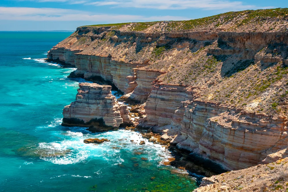
The expedition culminates in Kalbarri, a region where the Murchison River meets the Indian Ocean. The landscape here is dominated by the Kalbarri National Park, which recently underwent significant infrastructure upgrades, including the $24 million Kalbarri Skywalk. These twin cantilevered platforms extend 25 and 17 meters over the edge of the Murchison Gorge, providing views of the 400-million-year-old Tumblagooda Sandstone.
The geological history of Kalbarri is visible in the "skolithos" fossils—ancient worm tunnels preserved in the rock walls—and formations such as Nature’s Window and Z-Bend. The town itself has shown significant resilience, particularly following the devastation caused by Tropical Cyclone Seroja in 2021. The recovery efforts have seen a revitalization of local hospitality and tourism services, with a focus on sustainable development that respects the surrounding wilderness.
Broader Implications and Environmental Management
The growth of tourism along the Indian Ocean Drive necessitates a sophisticated approach to environmental management. The increase in 4WD traffic, particularly in sensitive areas like Stockyard Gully Caves and the Lancelin dunes, poses risks to soil stability and local flora. State authorities continue to invest in "reef-friendly" initiatives and strictly managed camping sites, such as those at Cliff Head, to mitigate the human footprint on the Coral Coast.
Furthermore, the economic reliance on seasonal tourism makes the region vulnerable to climate variability. A delay in the winter rains can significantly impact the wildflower bloom and the subsequent revenue for local shires. As Western Australia continues to promote the "West is Best" narrative to international and domestic markets, the challenge remains to preserve the rugged, "salty" character of the coastline while providing the infrastructure necessary for a modern, high-volume tourist corridor.
The journey from Perth to Kalbarri represents a cross-section of Western Australia’s identity: a blend of ancient Indigenous heritage, a perilous maritime past, and a future defined by the careful stewardship of some of the world’s most unique natural assets.