
 Anjar Salim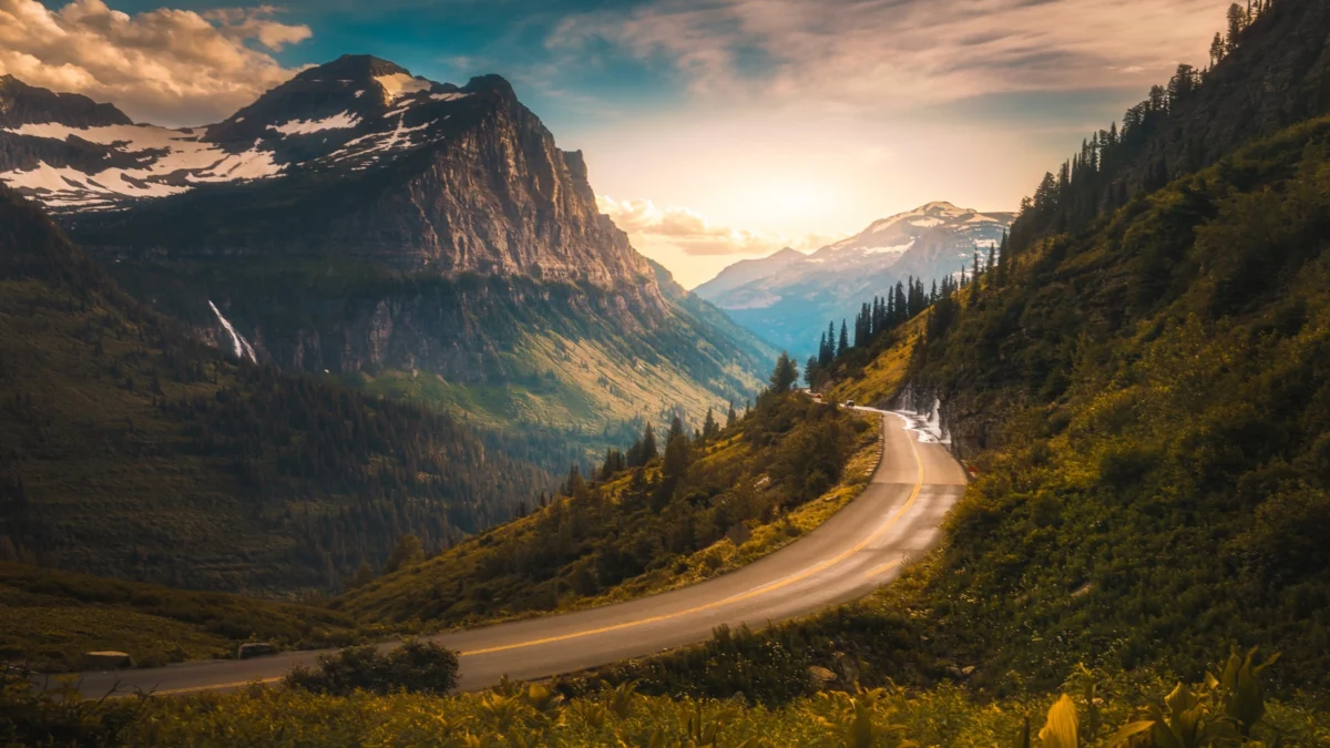
The National Park Service has initiated emergency protocols across Glacier National Park following a historic and prolonged rainstorm that has decimated infrastructure, triggered widespread evacuations, and forced the closure of the park’s most iconic thoroughfares. In what meteorologists are describing as a once-in-a-generation weather event for the northern Rocky Mountains, heavy precipitation beginning on June 28, 2026, has led to the immediate closure of Going-to-the-Sun Road and the total evacuation of the Many Glacier Valley. The deluge, which has transformed tranquil alpine streams into raging torrents, has left hundreds of visitors scrambling to adjust travel plans as officials warn of the heightened risk of rockslides, flash floods, and hypothermia in the backcountry.
As of June 30, 2026, the National Park Service (NPS) has issued an urgent plea for the public to avoid specific high-risk sectors of the park. The primary concern centers on rising floodwaters and the instability of steep terrain, which remains saturated and prone to sudden debris flows. The closure of Going-to-the-Sun Road—the 50-mile engineering marvel that serves as the park’s main artery—has effectively bisected the park, preventing trans-mountain travel and cutting off access to Logan Pass, the park’s highest point accessible by vehicle.
Chronology of the Weather Event and Emergency Response
The crisis began in the late hours of June 27 and intensified throughout June 28, as a stagnant low-pressure system drew moisture from the Pacific Northwest, dumping several inches of rain over the Crown of the Continent ecosystem. By the afternoon of June 28, park officials realized the severity of the situation as culverts reached capacity and water began overtopping sections of Going-to-the-Sun Road.
The decision to close the road was made at approximately 3:00 PM on June 28, following reports of debris and small rockslides near the "Big Bend" and "The Weeping Wall" areas. Simultaneously, in the northeastern corner of the park, the Many Glacier Valley experienced rapid water level rises in Swiftcurrent Lake and Lake Josephine. By the morning of June 29, the NPS moved to evacuate the Many Glacier Hotel, a historic Swiss-style chalet, along with the Swiftcurrent Motor Inn and the Many Glacier Campground. These facilities, which can accommodate upwards of 1,000 visitors and staff daily, were cleared as a precautionary measure against potential road washouts that could have stranded occupants.
"The park urges visitors to practice responsible visitation during this weather event," the National Park Service stated in an official release. "Flooded areas should never be crossed, and all posted closures must be followed. Travelers should check current conditions before arriving and remain flexible with plans as weather and access may change quickly."
Infrastructure and Economic Impact
The timing of the storm is particularly devastating for the local economy and the National Park Service’s operations. Late June marks the beginning of the peak tourism season, a period when Glacier National Park typically sees tens of thousands of visitors per day. The closure of Going-to-the-Sun Road is not merely a logistical hurdle but a significant blow to the regional tourism industry, which relies heavily on the accessibility of the park’s interior.
Anthony Nelson, executive director of the Glacier Institute, a non-profit partner of the park, highlighted the emotional and logistical toll on visitors. "There is a lot of water," Nelson said in an interview. "It’s definitely a downer when Going-to-the-Sun Road is closed and you’ve planned your entire trip around the drive. We haven’t seen the full extent of the damage yet, and officials haven’t announced when the closures will be lifted."
Historical data suggests that such events can lead to prolonged closures. In previous years, major flooding in the Rocky Mountain region—most notably the 2022 floods in Yellowstone National Park—resulted in months of reconstruction and millions of dollars in infrastructure repair. While Glacier’s current situation is still being assessed, the NPS must wait for water levels to recede before engineers can inspect the structural integrity of bridges, retaining walls, and the roadbed itself.
Navigating the Closures: Strategies for Visitors
Despite the extensive closures, large portions of the park remain accessible to those willing to pivot their itineraries. The National Park Service and local experts are encouraging visitors to explore the periphery of the park, which often receives less foot traffic even during peak season.
Anthony Nelson recommends that visitors shift their focus to the southern and eastern boundaries of the park. "If you’re planning a visit, stop at lesser-known trails," Nelson advised. "These areas are home to wildlife that showcases the picturesque Rocky Mountain landscape without the crowds or the current hazards of the high-elevation passes."
One primary recommendation is Firebrand Pass, located on the park’s southern edge. This six-mile trail begins south of East Glacier Park Village and offers a diverse ecological experience, winding through aspen groves and willow thickets before connecting with the Continental Divide Trail. Because this area sits at a lower average elevation and features different drainage patterns, it has remained more resilient to the recent rainfall.
Furthermore, the St. Mary entrance on the eastern side remains a viable gateway for certain activities. "Right now, you can get into the Jackson Glacier Overlook, and there are plenty of great wildlife opportunities to see over there," Nelson noted. He also pointed to the Beaver Pond Loop, a 3.3-mile trail near the St. Mary entrance. "It’s a pro tip—nobody knows it’s there, and it’s a fantastic spot to see bears and moose."
For those interested in the park’s unique fauna, the Goat Lick Overlook remains a high-priority destination. Located along Highway 2 on the park’s southern border, this natural mineral seep attracts mountain goats that congregate to consume essential salts. This area is generally unaffected by the road closures within the park’s interior.
Safety Protocols and Environmental Hazards
The National Park Service has emphasized that the current conditions are not merely inconvenient but potentially lethal. The combination of heavy rain and steep, rocky terrain creates a high probability of "flashy" hydrological responses, where small, seemingly insignificant streams can become impassable within minutes.
"Closures can happen quickly, and it can sometimes be easy to miss the signage," Nelson warned. "Be on the lookout for closures, stay aware, and take it seriously. Flash flooding is a huge deal, and you can find yourself in a dangerous situation quickly if you don’t follow posted guidelines and warnings."
Beyond the risk of drowning or being swept away by water, the NPS is warning backcountry hikers about the risk of hypothermia. Even in June, rain at high elevations in Montana is often accompanied by near-freezing temperatures. Wet clothing and wind exposure can lead to rapid heat loss. Park rangers are advising all hikers to carry "the ten essentials," including high-quality rain gear and emergency shelters.
Additionally, the displacement of wildlife due to flooding is a concern. Bears, including the park’s famous grizzly population, may move to different elevations or closer to human-populated areas to avoid flooded bottomlands. Nelson stressed the importance of carrying bear spray and knowing how to use it, regardless of the weather conditions.
Comprehensive List of Current Closures (As of June 30, 2026)
The following areas have been officially closed by the National Park Service until further notice:
- Going-to-the-Sun Road: Closed from the foot of Lake McDonald to St. Mary.
- Many Glacier Valley: Entire valley closed to all public access, including the Many Glacier Hotel, Swiftcurrent Motor Inn, and Many Glacier Campground.
- Ptarmigan Area: All trails leading to Ptarmigan Falls, the Ptarmigan Tunnel, and Ptarmigan Lake.
- Swiftcurrent Area: All trailheads originating from the Swiftcurrent Motor Inn parking lot.
- Piegan Pass: Closed from the Siyeh Bend trailhead to the Many Glacier junction.
- Red Gap Pass: Entirety of the pass closed due to saturated soils and high rockfall risk.
- Cracker Lake: Trailhead and the Cracker Lake Campground.
- Saddle Horse Corral: All operations suspended.
- South Shore Josephine Lake: Trail from the hotel to Oastler Shelter and the Josephine Walk.
- Grinnell Lake: Both the Horse Trail and Foot Trail, including the section from Oastler Shelter to Grinnell Lake.
- Running Eagle Falls: Access from Two Medicine Road to the falls is prohibited.
- Iceberg Trail: The Iceberg Lake Trailhead and all spur trails.
Analysis: The Broader Context of Alpine Flooding
The "historic" nature of this storm fits into a broader pattern of shifting climatic conditions in the American West. While Glacier National Park is accustomed to heavy snowpack and spring runoff, the increasing frequency of extreme rain-on-snow events and late-season heavy rainfall poses a significant challenge to the preservation of the park’s historic infrastructure.
Many of the park’s structures, including the Many Glacier Hotel and parts of Going-to-the-Sun Road, were built in the early 20th century. While robust, they were not necessarily designed to withstand the hydrological extremes being recorded in the 21st century. The NPS has been working on multi-year projects to "harden" infrastructure, but the sheer scale of the park—over one million acres—makes comprehensive protection impossible.
As the water recedes, the focus will shift from emergency management to damage assessment. The park’s geological team will be tasked with identifying new "slide zones" where the earth has been weakened. Until these assessments are complete, the NPS has indicated that it will err on the side of caution, prioritizing visitor safety over access.
For now, the message to the public remains one of patience and vigilance. As the National Park Service statement concluded: "Visitors are advised to expect disruptions from rain, including dangerous or impossible travel conditions. Authorities will continue to evaluate and reopen areas when conditions improve." Travelers are encouraged to monitor the official Glacier National Park website and social media channels for real-time updates as the situation evolves.


 Chandra Hamzah
 Tatiana Tantri Indah Sari
 Budi Mulyono
 Lukman Taruna Persada Ramadan