
 Walid Sujud Trenggono
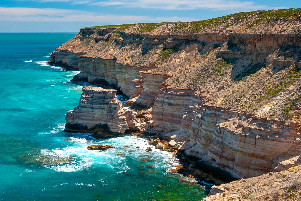
As the final winter rains recede north of Perth, the Western Australian coastline undergoes one of the planet’s most dramatic seasonal transformations. Stretching from the coastal dunes of Lancelin to the ancient gorges of Kalbarri, the Indian Ocean Drive opens up a corridor of ecological diversity, marine abundance, and indigenous heritage. This nearly 600-kilometre stretch of tarmac connects travellers to a dynamic landscape where the desert meets the sea, drawing thousands of domestic and international visitors during the peak tourism window from July to October.
The economic and ecological implications of this coastal tourism corridor are profound. According to regional tourism data from Tourism Western Australia, the Coral Coast highway acts as a vital economic lifeline for regional shires, channelling millions of dollars annually into local fisheries, hospitality ventures, and eco-tourism operations. As government investments continue to upgrade infrastructure along the fully sealed route—which officially spans 270 kilometres from Yanchep to Dongara before extending further north—regional stakeholders anticipate sustained growth in sustainable, nature-based travel.
Chronological Journey and Main Geographic Milestones
The expedition begins approximately 55 kilometres north of the Perth Central Business District, where the Indian Ocean Drive diverges from metropolitan sprawl into rolling golden pastures. Historically home to the Yued people of the Noongar nation, these lands hold deep spiritual and cultural significance that predates European maritime exploration by tens of thousands of years.
Moving northward, the chronological progression of the journey introduces travellers to distinct geological formations and marine ecosystems:
- Lancelin (Wangaree): Renowned for its western rock lobster fishery and towering, two-kilometre-long white sand dunes.
- Cervantes and Nambung National Park: Home to the globally recognised Pinnacles Desert, featuring thousands of limestone spires.
- Jurien Bay and Green Head: Celebrated for protected marine reserves, breeding colonies of Australian sea lions, and historical shipwrecks.
- Geraldton and Northampton: Centers of maritime tragedy commemoration, deep-sea exploration history, and the Chapman Valley’s expansive wildflower fields.
- Hutt Lagoon (Port Gregory): A hypersaline lake famous for its striking bubblegum-pink waters, driven by Dunaliella salina microalgae.
- Kalbarri and the Murchison River Gorge: The northern terminus of the route, characterised by towering sea cliffs, river-carved gorges, and structural skywalks.
Sand Surfing and Maritime Heritage at Lancelin
At the southern gateway of the trip lies Lancelin, known in the Yued language as Wangaree, meaning "fish." The town operates as a dual hub for commercial rock lobster fishing and high-adrenaline coastal recreation. Before afternoon sea breezes turn the bay into a premier destination for kiteboarding and windsurfing, the calm, shallow waters shelter the Lancelin Island Nature Reserve, situated 700 metres offshore.
The marine ecosystem surrounding the island is exceptionally fragile yet historically treacherous. Local maritime historians note that the surrounding reef systems hold the remains of 14 historical shipwrecks, contributing to a world-famous dive trail. On land, the economic driver shifts toward adventure tourism. The northern sand dunes—reaching heights of up to two kilometres—attract thousands of visitors annually who engage in sandboarding, off-road vehicle driving, and quad biking. Regional tourism operators emphasize the importance of managed access to these dunes to protect underlying archaeological sites while supporting local recreation-based enterprises.
The Geological Enigma of the Pinnacles Desert
Further north in Nambung National Park near Cervantes, the landscape shifts dramatically into a surreal plain of limestone pillars known as the Pinnacles. Rising up to four metres from the shifting golden sands of the Swan Coastal Plain, these spires have fascinated scientists and explorers for centuries. Early Dutch navigators famously mistook the weathered columns for the ruins of an abandoned ancient city.
Geological surveys indicate that the Pinnacles were formed approximately 25,000 to 30,000 years ago, following the receding of the sea and the accumulation of seashell fragments into rich coastal lime deposits. Over millennia, acidic rainwater dissolved the softer limestone, leaving behind the hardened vertical pillars exposed by wind erosion. In Yued folklore, these formations are intrinsically tied to the journey of Wagyl, the rainbow serpent, who shaped the region’s rivers and landmarks.
Today, Nambung National Park represents a major conservation priority for the Department of Biodiversity, Conservation and Attractions (DBCA). Park management balances vehicular access via the Pinnacles Desert Loop Drive with pedestrian boardwalks designed to protect the delicate root systems of native acacias and prevent erosion of the fragile landscape.
Biodiversity and Conservation in Jurien Bay
Transitioning from desert landscapes to marine environments, Jurien Bay offers a critical sanctuary for the endangered Australian sea lion (Neoph cinerea). Approximately 800 individuals comprise the local breeding population, hauling out on isolated offshore islands including Buller Island, North Fisherman Island, and Essex Rocks.
Access to these breeding grounds is strictly regulated by environmental authorities to minimise human disturbance. Conservation biologists stress that managing marine tourism is vital for the survival of the species, which faced historical declines due to sealing in the 19th and early 20th centuries. Visitors can legally observe the marine mammals through regulated eco-tours that also highlight the extensive seagrass meadows supporting the region’s lucrative western rock lobster fishery.
Further along the coast at Green Head, the protected waters of Dynamite Bay connect modern travellers with maritime history. The bay derives its name from 1960s treasure hunters who utilised Dutch archival maps and explosives to recover silver bullion from the wreck of the Vergulde Draeck (Gilt Dragon), which struck a coral reef and sank offshore in 1656. Nearby, the Stockyard Gully Caves provide an underground adventure through ancient, water-carved limestone tunnels, protected as a dedicated nature reserve requiring four-wheel-drive access.
Shipwrecks, Memorials, and Botanical Diversity in Geraldton
As the Indian Ocean Drive merges with the Brand Highway, travellers reach Geraldton, a coastal city deeply rooted in Western Australia’s maritime past. The Western Australian Museum – Geraldton houses extensive artifacts recovered from notorious Dutch East India Company (VOC) shipwrecks, including the Batavia, which was the site of a bloody mutiny and massacre following its wreck in 1629.
Overlooking the city from a prominent hilltop is the HMAS Sydney II Memorial, a solemn architectural tribute commemorating the 645 Australian sailors who lost their lives when the light cruiser was sunk by the German auxiliary cruiser Kormoran during World War II in November 1941. The memorial serves as a focal point for national remembrance and historical education.
Inland from Geraldton, the Chapman Valley and Northampton regions host a staggering botanical display. Horticultural experts note that Western Australia is home to over 12,000 species of wildflowers, roughly 60 percent of which are endemic to the state. During the peak spring bloom from July to October, the roadside verges and agricultural lands explode into color, featuring rare varieties such as the wreath flower (Leschenaultia macrantha), which grows in horizontal garlands directly upon the soil.
The Pink Waters of Hutt Lagoon and the Mouth of the Murchison
Continuing northward, Hutt Lagoon near Port Gregory provides a striking visual spectacle. The lake’s characteristic bubblegum-pink hue is the result of high concentrations of the beta-carotene-producing microalgae Dunaliella salina. Commercial harvesting of the algae for use in natural food colorants and dietary supplements operates on the shores of the lagoon, representing a unique intersection of industrial biotechnology and eco-tourism. Environmental scientists note that the vibrancy of the pink coloration fluctuates based on cloud cover, solar intensity, and seasonal microalgae population densities.
The northern terminus of the coastal corridor is anchored by Kalbarri and the mouth of the Murchison River. The region’s geological architecture is defined by red-brown Tumblagooda sandstone, sculpted by wind and water over 400 million years. Coastal attractions such as the Kalbarri Skywalk—suspended 100 metres above the Murchison River Gorge—and Nature’s Window draw hundreds of thousands of visitors annually, necessitating careful engineering and safety protocols managed by local authorities.
Local Hospitality and Economic Resilience
The influx of visitors along the Indian Ocean Drive has spurred sustainable economic development within regional communities. Small businesses, ranging from historic hospitality venues like Finlays Kalbarri to boutique eco-accommodations such as Sols Place, have adapted to meet the demands of travellers seeking authentic, nature-focused experiences.
Regional tourism bodies and local shires continue to collaborate on infrastructure maintenance, waste management, and conservation initiatives to ensure that the delicate balance between visitor accessibility and ecological preservation is maintained. As government and private sectors look to the future, the Indian Ocean Drive remains a cornerstone of Western Australia’s regional tourism strategy, offering a resilient blueprint for sustainable coastal development.


 Gabriela Annisa
 Lukman Taruna Persada Ramadan
 Tatiana Tantri Indah Sari

 Anjar Salim

 Dwi Wanna
