Navigating the labyrinthine streets of New York City is a challenge for even the most seasoned motorists, but the task of finding a legal parking space in Manhattan often borders on the impossible. Amidst a dense landscape of high-rise commercial buildings, bustling social hubs, and rigorous traffic enforcement, the search for a curbside spot frequently results in frustration or costly citations. To mitigate this long-standing urban struggle, the New York City Department of Transportation (DOT) has developed and refined an interactive digital resource designed to provide drivers with unprecedented access to the city’s complex web of parking regulations.
The tool, an interactive map hosted on the official nycdotsigns.net portal, serves as a comprehensive database of the hundreds of thousands of parking signs distributed across the five boroughs. By digitizing the physical signage that dictates the flow of the city’s curb space, the DOT aims to improve transparency and reduce the ambiguity that often leads to unintentional traffic violations. This initiative represents a significant step in the modernization of New York City’s infrastructure management, leveraging geographic information systems (GIS) to assist the millions of drivers who navigate the city’s 6,000 miles of streets annually.
The Technical Framework of the Interactive Parking Map
The digital tool is built upon the Street Integrated Management System (SIMS), a sophisticated backend database maintained by the New York City Department of Transportation. This system serves as the central repository for every piece of signage installed by the city, ranging from speed limits and one-way indicators to the highly specific parking regulations that govern Manhattan’s financial district and residential neighborhoods.
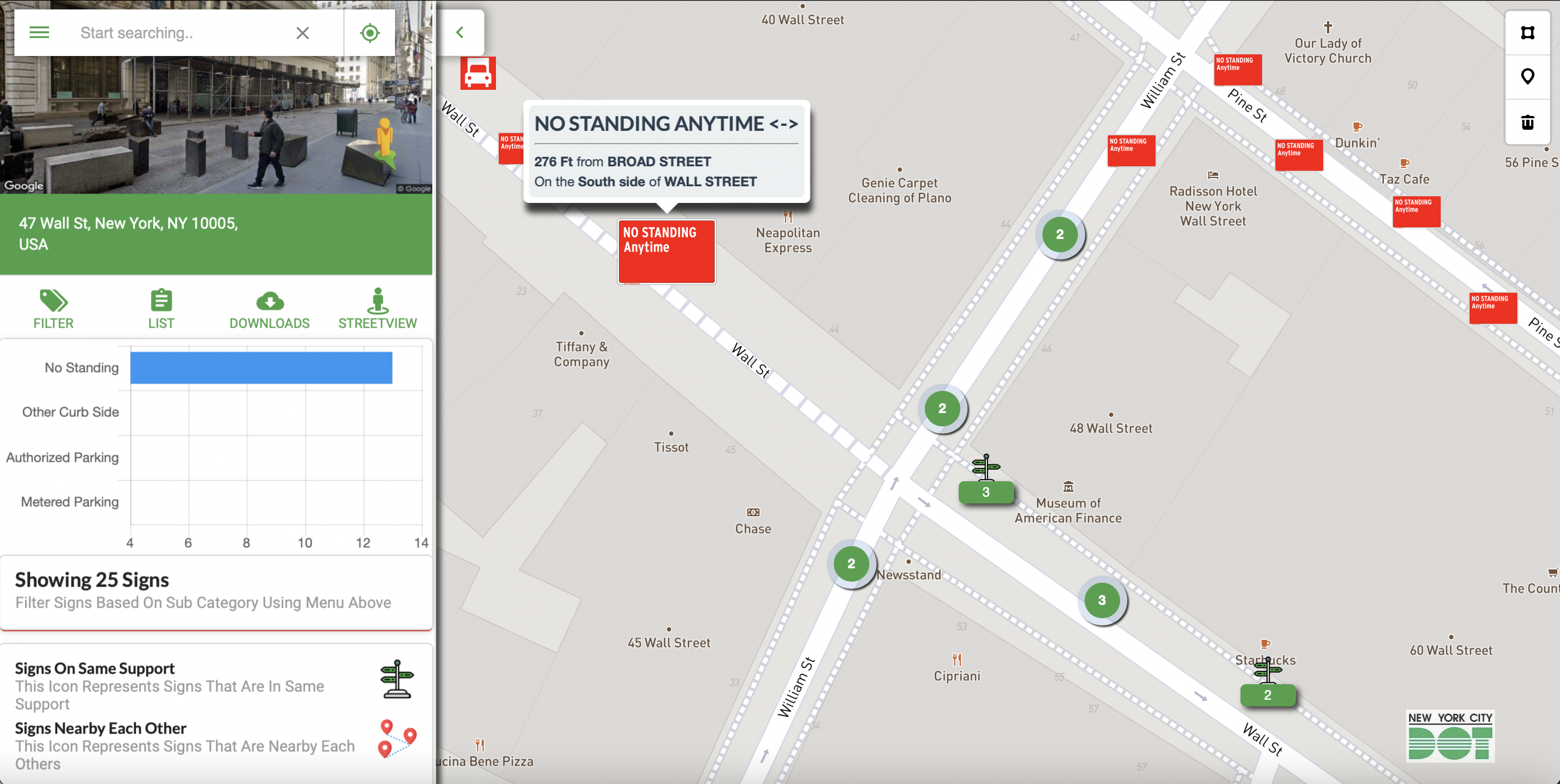
When users access the interactive map, they are presented with a high-resolution interface that allows them to zoom into specific blocks or search for particular intersections. Each parking sign is represented by a digital marker. By hovering a cursor over these markers or clicking on specific street segments, users can view the exact language printed on the physical sign. For instance, a driver looking to park on Wall Street west of William Street can identify specific "No Standing" zones and see the precise distance—such as 276 feet from Broad Street—where the restriction applies.
This level of detail is particularly critical in New York City, where a single block may be subject to four or five different regulations depending on the time of day, the day of the week, or the type of vehicle involved. The tool also incorporates data from the Department of City Planning’s Geosupport system, ensuring that the geographic coordinates of the signage align with the city’s official tax maps and street grids.
Decoding New York City’s Parking Hierarchy
A primary source of confusion for drivers in New York City is the subtle but legally significant distinction between different types of restrictive signage. The interactive tool helps clarify these rules, which are codified under Title 34, Chapter 4 of the Rules of the City of New York. Understanding these definitions is essential for avoiding the city’s aggressive towing and ticketing apparatus.

The hierarchy of restrictions is generally categorized into three tiers:
- No Parking: This is the least restrictive of the three. Drivers are permitted to stop temporarily to expeditiously load or unload packages or merchandise. They may also stop to pick up or discharge passengers. However, the driver cannot leave the vehicle unattended, and the process must be active and continuous.
- No Standing: This regulation is more restrictive. Drivers are permitted to stop only to quickly receive or discharge passengers. Unlike "No Parking" zones, drivers in "No Standing" areas are prohibited from waiting for passengers or loading/unloading goods or bundles.
- No Stopping: This is the most stringent restriction. Under no circumstances is a vehicle allowed to halt in these zones, even momentarily. This includes stopping to drop off a passenger or checking a GPS device. These zones are typically reserved for high-traffic corridors, bus lanes, or areas near fire hydrants and critical infrastructure.
By providing the exact text of these signs through the interactive tool, the DOT allows drivers to plan their arrivals with a clear understanding of whether they are permitted to linger at a specific curb.
The Economic and Logistical Scale of NYC Parking
The necessity for such a tool is underscored by the sheer volume of parking enforcement activity in the city. New York City consistently generates over $1 billion annually in revenue from parking tickets and camera-based traffic fines. In a typical fiscal year, the New York Police Department (NYPD) and the Department of Finance process millions of citations. A significant portion of these fines stems from "Alternate Side Parking" (ASP) violations, which are necessary for the city’s Department of Sanitation to perform street sweeping.
The interactive map serves as a vital companion to the city’s ASP schedule. While the map shows permanent signage, it allows users to verify the specific hours during which street cleaning occurs on any given block. For the business community, particularly the thousands of delivery drivers who keep the city’s economy moving, the tool provides a way to identify commercial loading zones, potentially reducing the frequency of double-parking—a major contributor to Manhattan’s chronic traffic congestion.
Chronology of Digital Transparency in City Management
The development of the interactive parking tool is part of a broader, decade-long push toward "Open Data" in New York City government.
- 2012: The New York City Council passed the Open Data Law, requiring all public data to be made available on a single web portal.
- 2015–2018: The DOT began migrating its internal SIMS data to a public-facing GIS format. During this period, the city focused on digitizing the "Signs Database," which includes more than one million signs across the five boroughs.
- 2020: The COVID-19 pandemic shifted the city’s focus toward "Open Restaurants" and outdoor dining, which necessitated rapid changes to parking regulations. The digital map became an essential tool for tracking these temporary curb-use changes.
- 2022–Present: The tool underwent significant updates to improve mobile compatibility and user interface responsiveness, acknowledging that most drivers access the information while already in their vehicles.
Broader Implications for Urban Mobility and the Environment
Beyond the immediate convenience for drivers, the interactive parking tool has broader implications for urban planning and environmental sustainability. Research into urban "cruising"—the act of driving around in circles while looking for a parking spot—suggests that this behavior accounts for a significant percentage of traffic congestion in major metropolitan areas.
Studies have estimated that in high-density areas like Midtown Manhattan, up to 30% of traffic consists of drivers searching for parking. This adds thousands of tons of unnecessary carbon dioxide emissions to the atmosphere and increases the risk of collisions with pedestrians and cyclists. By allowing drivers to identify legal spots or understand restrictions before they arrive at their destination, the DOT’s interactive tool serves as a "smart city" solution to reduce idle driving and improve overall traffic flow.
Furthermore, the data provided by this tool is increasingly being utilized by third-party app developers and logistics companies. By integrating the DOT’s sign data into navigation software, delivery fleets can optimize their routes to prioritize blocks with available commercial standing zones, thereby reducing the "last-mile" delivery friction that often paralyzes New York’s narrow side streets.
Official Guidance and Regulatory Caveats
Despite the high level of detail provided by the SIMS and the interactive map, the New York City Department of Transportation maintains a strict disclaimer regarding the tool’s use. The city emphasizes that the information is provided for informational purposes and that the physical signage on the street always takes legal precedence.
The DOT notes that parking regulations are subject to temporary or permanent changes that may not be reflected in the digital database in real-time. Emergency construction, film shoots, parades, and presidential visits frequently result in temporary "No Parking" zones that are marked by paper signs taped to existing poles. The public is advised that the interactive tool is a supplement to, rather than a replacement for, a diligent observation of the physical environment.
In official statements, the DOT has clarified that a discrepancy between the digital map and a physical sign is not a valid defense in a parking ticket appeal. The city’s Geosupport system is described as a "pre-release version" in some contexts, and the city disclaims any liability for omissions or errors within the application.
Conclusion: A New Era of Curb Management
As New York City continues to evolve, the competition for curb space has intensified. The rise of ride-sharing services, the expansion of bike lanes, and the permanent installation of outdoor dining structures have reduced the number of traditional parking spots available to private motorists. In this high-stakes environment, the interactive parking tool is an essential utility for navigating the modern city.
By bridging the gap between complex municipal law and the daily needs of the motoring public, the New York City Department of Transportation has provided a model for how data-driven governance can improve the quality of urban life. While it may not solve the fundamental shortage of space in a city of 8.5 million people, it provides the transparency necessary to make the most of the space that remains. For those brave enough to drive in Manhattan, this digital map is perhaps the most valuable tool in their glovebox—or more accurately, on their smartphone.