
 Walid Sujud Trenggono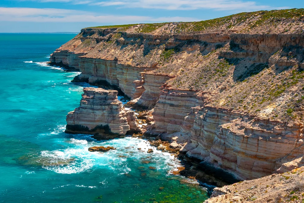
The Indian Ocean Drive and its northern extensions represent one of Australia’s premier touring corridors, offering a diverse array of geological formations, marine ecosystems, and botanical wonders. Spanning hundreds of kilometers from just north of Perth to the rugged gorges of Kalbarri, this coastal route traverses ecosystems ranging from white-sand coastal deserts and limestone cave networks to vibrant marine sanctuaries and wildflower-rich pastures. Regional tourism authorities report that self-drive tourism along this coastal corridor contributes significantly to Western Australia’s domestic visitor economy, drawing hundreds of thousands of travelers annually who seek a combination of soft adventure, natural history, and coastal leisure.
Chronology and Route Architecture
The journey typically commences north of the Perth Central Business District, joining the fully sealed Indian Ocean Drive approximately 55 kilometers out. Constructed to improve regional connectivity and boost tourism, the 270-kilometer stretch from Yanchep to Dongara forms the foundational highway for coastal exploration, with an additional 230 kilometers required to reach Kalbarri further north.
Historically, this coastline served as a treacherous navigational hazard for 17th-century European maritime explorers. Navigational errors and uncharted reefs led to numerous shipwrecks, a legacy preserved in maritime museums and underwater dive trails. In the modern era, the corridor has evolved from a remote pastoral and fishing frontier into a meticulously mapped eco-tourism and adventure highway. Peak visitation occurs between July and October, coinciding with the arrival of the southern hemisphere spring, optimal weather conditions, and the mass blooming of Western Australia’s famous endemic flora.
Lancelin and the Southern Gateway
The southern leg of the journey begins at Lancelin, known in the local Yued Indigenous language as Wangaree, meaning "fish." The town supports a commercial fishing fleet targeting western rock lobster, dhufish, pink snapper, and yellowtail kingfish. Beyond its fisheries, Lancelin is recognized by sporting bodies as a premier destination for windsurfing, kiteboarding, and sand surfing.
The local geography features a two-kilometer-long system of coastal sand dunes on the northern edge of the town. These high-angle crests attract recreational users engaging in sandboarding, off-highway vehicle driving, and tobogganing. Offshore, the Lancelin Island Nature Reserve—situated 700 meters from the coast—acts as a protected habitat for seabirds and Australian sea lions. The surrounding marine environment contains fourteen documented historical shipwrecks, forming part of regional heritage dive trails managed by state maritime agencies.
Geological Marvels: The Pinnacles Desert
Moving north into Nambung National Park near Cervantes, the landscape shifts to the Swan Coastal Plain, home to the Pinnacles Desert. This geological site features thousands of limestone pillars rising up to four meters from shifting yellow quartz sands. According to Yued traditional custodians, the landscape is culturally significant, linked to oral histories of the Wagyl, the rainbow serpent, who shaped regional waterways and landmarks.
Early Dutch navigators encountering the spires in the 17th century mistook them for the structural ruins of an abandoned settlement. Modern geological studies indicate that the pillars are remnants of ancient marine limestone formations, sculpted by millennia of wind, rain, and root systems that eroded softer surrounding strata while leaving denser pillars exposed. The park management authority maintains the Pinnacles Desert Loop Drive to facilitate vehicular and pedestrian access while protecting the fragile underlying dune ecosystems from unmanaged foot traffic.
Marine Biodiversity and Conservation at Jurien Bay
Further north lies Jurien Bay, a marine biodiversity hotspot anchored by an 800-strong breeding colony of Australian sea lions distributed across isolated offshore reserves, including Buller Island, North Fisherman Island, and Essex Rocks. Due to conservation protocols enforced by the Western Australian Department of Biodiversity, Conservation and Attractions, public access to these breeding islands is restricted, and commercial operators must adhere to strict wildlife interaction guidelines.
The coastal waters surrounding Jurien Bay feature extensive seagrass meadows that serve as nurseries for western rock lobsters and various finfish species. Municipal and state conservation initiatives have established artificial reefs and underwater snorkeling trails—such as the interpretive trail deployed near the historic Jurien Bay jetty—to educate visitors on marine conservation while dispersing tourist pressure away from sensitive natural reefs.
Nearby at Green Head, the sheltered turquoise cove of Dynamite Bay bears historical ties to the 1656 shipwreck of the Dutch East India Company vessel Vergulde Draeck (Gilt Dragon). Maritime historians note that 20th-century recovery expeditions utilized archival charts and explosive charges to retrieve historical artifacts, cementing the area’s reputation within the state’s maritime archaeology narrative.
Subterranean Exploration at Stockyard Gully
Inland from the immediate coast, the Stockyard Gully Reserve offers subterranean exploration via a 250-meter-long limestone cave system. Formed by ancient hydrological activity along a subterranean watercourse, the tunnel features residual stalactite formations and mineral-stained rock walls.
Access to the cave requires four-wheel-drive capability and adequate safety lighting, as the interior is devoid of artificial illumination. Upon exiting the subterranean channel, visitors enter a protected gully supporting diverse flora, including zamia palms, flooded gums, and various native banksia species. Conservationists emphasize the ecological sensitivity of these limestone reserves, which provide critical habitats for nocturnal mammals such as the honey possum.
Maritime Heritage and Natural Phenomena in Geraldton and Beyond
As the Indian Ocean Drive terminates at its intersection with the Brand Highway, the touring route continues north toward Geraldton, the region’s commercial and cultural hub. The Western Australian Museum – Geraldton houses extensive exhibits dedicated to the 17th- and 18th-century Dutch shipwrecks—including the Batavia and the Vergulde Draeck—detailing incidents of mutiny, survival, and maritime disaster. Additionally, the city hosts the official HMAS Sydney II Memorial, a national monument honoring the loss of 645 Australian service personnel during World War II following an engagement with the German raider Kormoran in November 1941.
Further inland and along agricultural routes such as the Chapman Valley Scenic Drive, the landscape transforms during the spring wildflower season. Botanists estimate that Western Australia hosts over 12,000 species of flora, a high percentage of which are endemic. Varieties such as everlasting daisies, wreath flowers, and various orchids blanket road verges and agricultural borders, drawing botanists and nature photographers from across the globe.
Along the coast near Hutt Lagoon, commercial microalgae production facilities operate alongside natural saline flats. The water’s distinctive pink coloration is caused by the presence of Dunaliella salina, a beta-carotene-producing microalgae. The intensity of the pink hue fluctuates depending on solar radiation, cloud cover, and seasonal algae concentration, making the lagoon a notable subject for both ecological study and regional tourism marketing.
The Gorges and Coastal Cliffs of Kalbarri
The northern terminus of the coastal touring route is Kalbarri, situated at the mouth of the Murchison River. The surrounding Kalbarri National Park encompasses deeply incised sandstone gorges and towering coastal cliffs formed over millions of years through geological uplift and fluvial erosion.
Key infrastructure projects by the state government, including the Kalbarri Skywalk—two cantilevered viewing platforms projecting 100 meters above the Murchison River gorge—have increased accessibility to the park’s interior. Geological features such as Nature Window frame the river landscape, while coastal formations like Eagle Gorge and the Blue Holes marine sanctuary showcase fossilized Skolithos tubes and tide pool ecosystems. The Murchison River mouth itself provides a sheltered estuarine environment for recreational fishing, kayaking, and boating, supported by local commercial hospitality providers offering regional seafood delicacies.
Economic and Practical Implications
The continuous development of sealed roadways, eco-accommodation, and interpretive facilities along the Indian Ocean corridor reflects a broader state strategy to promote regional dispersal of tourism revenue. Industry analysts note that self-drive itineraries provide economic resilience for small coastal hamlets by extending average visitor length of stay.
However, local authorities continuously balance tourism promotion with environmental management, particularly regarding off-road vehicle usage in fragile dune systems, protection of marine breeding colonies, and preservation of rare botanical reserves. Travelers embarking on the route are advised by regional safety organizations to carry adequate emergency supplies, monitor seasonal weather patterns, and respect designated conservation boundaries to ensure the long-term sustainability of Western Australia’s coastal ecosystems.

 Susilo Edi Turonggo
 Cholid Fahmi Thalib
 Budi Mulyono
 Lukman Taruna Persada Ramadan
 Anjar Salim