The Indian Ocean Drive, a 270-kilometer stretch of sealed road connecting the northern reaches of Perth to the mid-west town of Dongara, has redefined regional tourism in Western Australia since its completion in September 2010. Extending the journey to Kalbarri, approximately 600 kilometers north of the state capital, travelers encounter a diverse landscape characterized by shifting sand dunes, ancient limestone formations, and a marine environment of global ecological significance. This coastal corridor serves not only as a recreational thoroughfare for approximately 600,000 visitors annually but also as a vital link for the state’s multi-million-dollar rock lobster industry and a gateway to the UNESCO-recognized biodiversity of the Coral Coast.
Geographical and Infrastructural Overview
The development of the Indian Ocean Drive was a strategic infrastructure project designed to bypass the heavy haulage routes of the Brand Highway, providing a safer and more scenic alternative for light vehicles. Starting approximately 55 kilometers north of Perth’s Central Business District, the route traverses the traditional lands of the Yued and Amangu people. The landscape is defined by the Swan Coastal Plain, an area of high endemism where the Mediterranean climate facilitates one of the most spectacular wildflower displays on Earth. Between July and October, the region sees the emergence of over 12,000 species of flora, many of which are found nowhere else.
The Southern Gateway: Lancelin and the Yued Heritage
The first major waypoint, Lancelin, is known to the Yued Indigenous people as Wangaree, meaning "fish." This nomenclature reflects the town’s historical and contemporary reliance on marine resources. Lancelin operates as a primary hub for the Western Rock Lobster (Panulirus cygnus) fishery. According to the Department of Primary Industries and Regional Development, the Western Rock Lobster fishery is the first in the world to be certified as sustainable by the Marine Stewardship Council (MSC).
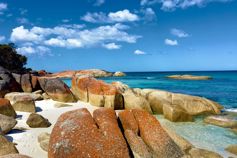
Beyond industry, Lancelin is defined by its massive white sand dunes, which rise up to 45 meters. These dunes are geologically active, shifting several meters each year due to the "Fremantle Doctor," the strong afternoon sea breeze that characterizes the Western Australian coastline. This wind also makes Lancelin a premier destination for windsurfing and kiteboarding, attracting international athletes during the summer months. Offshore, the Lancelin Island Nature Reserve provides a critical sanctuary for the Australian sea lion and various migratory seabird species, managed under strict conservation protocols by the Department of Biodiversity, Conservation and Attractions (DBCA).
Geological Phenomena: The Nambung National Park
North of Lancelin lies the town of Cervantes, the entry point to Nambung National Park. The park is home to the Pinnacles Desert, an expanse of thousands of limestone spires rising from the yellow sand. Geologists suggest these formations are the remains of the Tamala Limestone, created approximately 25,000 to 30,000 years ago after the sea receded and left deposits of seashells. Over millennia, coastal winds removed the surrounding loose sand, exposing the pillars.
For the Yued people, the Pinnacles hold deep cultural significance, often associated with the Wagyl, the Rainbow Serpent of Noongar Dreaming, who is said to have created the landscape’s water sources and landforms. To preserve this site, the Pinnacles Desert Discovery Centre was established to provide interpretive data on the park’s natural and cultural history. Tourism WA reports that Nambung National Park remains one of the most visited natural attractions in the state, necessitating ongoing management to balance visitor impact with geological preservation.
Marine Biodiversity and Jurien Bay
Continuing north, Jurien Bay serves as a focal point for marine conservation. The Jurien Bay Marine Park, established in 2003, covers approximately 82,375 hectares. It protects an extensive limestone reef system and seagrass meadows that are essential for the lifecycle of various marine species.
A primary attraction in this region is the Australian sea lion (Neophoca cinerea), one of the rarest pinnipeds in the world. Breeding colonies are located on Buller Island and North Fisherman Island. Access to these islands is strictly prohibited to prevent human interference with breeding cycles, though licensed eco-tourism operators provide controlled interaction opportunities. Supporting data from the DBCA indicates that these populations are highly vulnerable to environmental changes, making the marine park’s zoning—which includes "no-take" sanctuary zones—critical for their survival.
Maritime History and the "Gilt Dragon"
The coastline between Green Head and Leeman is steeped in maritime history, particularly regarding the "Age of Discovery." In 1656, the Dutch East India Company (VOC) ship Vergulde Draeck (Gilt Dragon) struck a reef near Ledge Point. The wreck resulted in the loss of 118 lives and a substantial cargo of silver coins. In the 1960s, treasure hunters used controversial methods, including explosives, to recover artifacts.
Today, the region emphasizes archaeological preservation. The "mouthful of sand" (Cuencandjaa in Yued) at Dynamite Bay in Green Head remains a testament to this era. Further inland, Stockyard Gully National Park features a 250-meter-long limestone tunnel, part of an ancient karst system. This tunnel historically served as a stock route for drovers moving cattle between Geraldton and Perth, highlighting the region’s colonial agricultural roots.
Geraldton: A Hub of Commemoration and Industry
Geraldton, the largest regional city on the route, serves as the administrative and economic heart of the Mid West. The city’s history is inextricably linked to the sea, both as a port for grain and mineral exports and as a site of maritime tragedy. The HMAS Sydney II Memorial, situated on Mount Scott, commemorates the 645 sailors lost in 1941 during a World War II battle with the German raider Kormoran. The memorial is a site of national significance, featuring a dome of 645 stainless steel gulls representing the lost souls.
The Museum of Geraldton provides further context, housing the wreck of the Batavia, a VOC ship that foundered in 1629 on the nearby Abrolhos Islands. The ensuing mutiny and massacre remain one of the darkest chapters in maritime history, and the museum’s preservation of the Batavia’s stern timbers is a feat of modern conservation science.
The Chemistry of Hutt Lagoon
Located between Northampton and Kalbarri, Hutt Lagoon offers a striking visual contrast to the blue of the Indian Ocean. The lagoon is a salt lake with a distinct pink hue caused by the presence of the carotenoid-producing algae Dunaliella salina. This site is not merely a photographic landmark but a significant industrial asset.
The lagoon is home to the world’s largest microalgae production plant, managed by BASF. The algae are harvested for beta-carotene, which is used globally as a natural food coloring and a source of Vitamin A. The intensity of the pink color fluctuates based on salinity levels, temperature, and light intensity, providing a real-time display of biological response to environmental conditions.
Kalbarri and the Murchison River Gorge
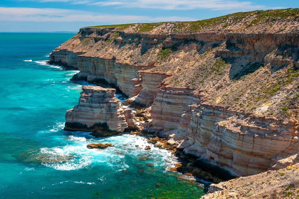
The journey concludes at Kalbarri, where the Murchison River meets the Indian Ocean. The Kalbarri National Park, spanning 183,000 hectares, is characterized by dramatic red sandstone gorges carved by the river over 400 million years. Notable formations such as Nature’s Window and the Z Bend provide windows into the Tumblagooda Sandstone, which contains some of the world’s oldest evidence of land-dwelling animals in the form of fossilized tracks (euryptids).
In 2020, the Western Australian government invested $24 million in the Kalbarri Skywalk, two cantilevered platforms that extend 25 and 17 meters over the Murchison Gorge. This project was designed to enhance tourism infrastructure while providing a safe, accessible way for visitors to experience the scale of the landscape.
Official Responses and Economic Impact
Tourism Western Australia has identified the Coral Coast, including the Indian Ocean Drive, as a "hero" destination for the state’s "Wander Out Yonder" and "Drive the Dream" campaigns. A spokesperson for the regional tourism board noted that the drive-to-market has become increasingly important for the economic resilience of coastal hamlets. "The Indian Ocean Drive is more than a road; it is a corridor of economic opportunity that supports hundreds of small businesses, from boutique accommodation in Lancelin to specialized tour operators in Kalbarri," the statement read.
However, the increase in traffic has prompted calls from local councils for continued investment in road safety and environmental protection. The Shire of Northampton and the Shire of Dandaragan have both advocated for increased funding to manage waste and maintain coastal trails, ensuring that the surge in visitor numbers does not degrade the very natural assets that attract them.
Analysis of Implications
The Indian Ocean Drive represents a successful integration of infrastructure, conservation, and economic development. By providing access to once-remote areas, the state has diversified its tourism portfolio beyond the traditional hubs of the South West. However, the region faces challenges from climate change, particularly coastal erosion and the warming of the Leeuwin Current, which could impact the rock lobster and sea lion populations.
The future of the region likely lies in "regenerative tourism," where the focus shifts from high-volume visitation to high-value, low-impact experiences. As Western Australia continues to position itself as a global leader in nature-based travel, the Indian Ocean Drive will remain a critical case study in how a developed nation manages its wild frontiers while honoring its Indigenous heritage and maritime history.