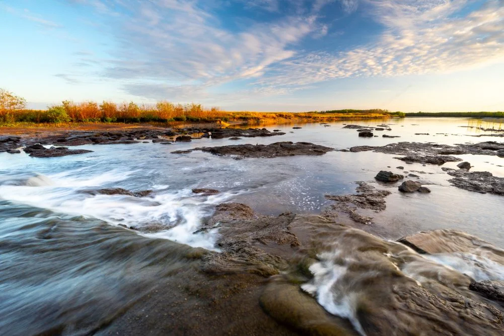
Located approximately 150 kilometers east of Darwin, the Mary River National Park stands as one of the Northern Territory’s most ecologically significant and recreationally vital landscapes. Characterized by a complex mosaic of lily-fringed lagoons, vast verdant floodplains, dense monsoon forests, and tidal reaches, the region offers a stark contrast to the urbanized comforts of the Northern Territory’s capital. The park is renowned globally for harboring the highest concentration of estuarine crocodiles (Crocodylus porosus) on the planet, a fact that both draws international tourists and necessitates a rigorous approach to safety and conservation management.
The Mary River system serves as a critical catchment area, draining into the Arafura Sea. Unlike many other river systems in the Top End, the Mary River does not have a single main channel that reaches the ocean; instead, it diffuses into a massive network of wetlands. This unique geography has created a sanctuary for a diverse array of flora and fauna, making it a primary destination for anglers, birdwatchers, and researchers.
Ecological Infrastructure: The Shady Camp Barrage
Central to the management of the Mary River Wetlands is Shady Camp, a site that serves as both a recreational hub and a critical point of environmental intervention. In the late 1980s, a concrete barrage was constructed across the river. This infrastructure was designed as a defensive measure against saltwater intrusion, a process that threatened to destroy the fragile freshwater ecosystems upstream. As sea levels rose and feral buffalo tracks exacerbated erosion, saltwater began to penetrate deep into the freshwater marshes, killing off vast tracts of paperbark forests and lotus lilies.
While the barrage acts as a physical barrier to the tide, it remains a porous boundary for the region’s apex predators. Estuarine crocodiles frequently traverse the structure, moving between the tidal saltwater reaches and the freshwater billabongs. This creates an unusual environment where anglers often stand in close proximity to large predators, particularly during the transition between the wet and dry seasons.
The environmental impact of the barrage has been a subject of ongoing study by Northern Territory Parks and Wildlife. While it has successfully preserved the freshwater integrity of the upper Mary River, it has also created a bottleneck for migratory fish species. This ecological "choke point" is a primary reason for the region’s fame as a premier fishing destination.
The Barramundi Run-off and Economic Significance
The "run-off" refers to the period at the end of the wet season (typically March to May) when the massive volume of water accumulated on the floodplains begins to drain into the main river channels. This seasonal movement triggers a biological frenzy. As the water recedes, it carries millions of baitfish and crustaceans over the Shady Camp barrage.
Waiting for this influx are Barramundi (Lates calcarifer), the Northern Territory’s most prized sport fish. The concentration of Barramundi at the barrage attracts thousands of recreational anglers annually, contributing significantly to the local tourism economy. However, the anglers are not alone in their pursuit. Large estuarine crocodiles, some exceeding five meters in length, congregate at the base of the barrage to intercept the fish.
This intersection of high-stakes fishing and wildlife observation defines the Mary River experience. Beyond Barramundi, the river supports populations of Saratoga, Sooty Grunter, and Tarpon. The economic value of this fishery has prompted the Northern Territory government to implement strict management zones to ensure the sustainability of fish stocks while allowing for the continued growth of the guided fishing safari industry.
Historical Chronology: The Legacy of John McDouall Stuart
The human history of the Mary River is as storied as its natural history. The naming of Shady Camp is attributed to the explorer John McDouall Stuart, who reached the area in 1862 during his sixth and final expedition. Stuart was the first European to successfully lead a party across the Australian continent from south to north and return alive.
Stuart’s journey, spanning over 3,500 kilometers from Port Augusta to the Arafura Sea, was instrumental in opening the Australian interior for telegraph communication and pastoral development. After a night spent at what is now Shady Camp, Stuart and his party pushed through the final coastal thickets to reach the beach at Chambers Bay. Today, the Stuart’s Tree Memorial Cairn stands as a testament to this feat, though accessibility to the site remains highly dependent on seasonal weather conditions.
For modern visitors, following Stuart’s footsteps requires a four-wheel-drive vehicle and careful timing. During the dry season, the Point Stuart Road provides access to the historical sites, but the tracks are frequently rendered impassable by the monsoonal rains of the wet season (October to April).
Biodiversity and Avian Habitats
The Mary River Wetlands are recognized under international conservation frameworks for their importance to migratory birds. The park’s diverse habitats—ranging from the Brian Creek and Jimmy Creek monsoon forests to the permanent waters of Mistake Billabong—support over 250 species of birds.
- Waterbirds: The floodplains are home to massive colonies of Magpie Geese, which can be seen in flocks numbering in the thousands. Other notable species include the Jabiru (Black-necked Stork), the only stork species found in Australia, and the Comb-crested Jacana, colloquially known as the "Jesus bird" for its ability to walk on floating lily pads.
- Monsoon Forest Species: The shaded enclaves of the monsoon forests provide a habitat for the Orange-footed Scrub-fowl, known for building enormous nesting mounds of organic debris. These forests also harbor Rainbow Bee-eaters and various species of kingfishers.
- Raptors: The abundance of fish makes the Mary River a prime hunting ground for the White-bellied Sea Eagle and the Whistling Kite.
The presence of the Floodplain Monitor and the Agile Wallaby further adds to the terrestrial biodiversity. Observation platforms at Couzens Lookout and Mistake Billabong allow visitors to view these species in a controlled environment, minimizing human impact on the sensitive wetland fringes.
Tourism Infrastructure and Management
Managing a landscape as volatile and dangerous as the Mary River requires significant infrastructure. The Northern Territory government utilizes a "user-pays" system, with entry fees and camping permits funding the maintenance of boat ramps, walking trails, and safety signage.
Accommodation and Facilities:
- Point Stuart Wilderness Lodge: This private facility provides a range of accommodation from safari tents to lodge rooms. It serves as a logistical base for boat rentals and guided wetland cruises.
- National Park Campgrounds: Facilities at Shady Camp and Couzens Lookout are designed for self-sufficient travelers. They include fire pits and wheelchair-accessible toilets, though visitors are required to bring their own drinking water and firewood.
Commercial Operations:
Several companies, including Wildlands and Corroboree Billabong Wetland Cruises, operate under strict licensing agreements. These tours are essential for visitors without private vessels, providing a safe means to observe crocodiles and birdlife from the water. Tours are typically conducted in open-air boats designed for maximum visibility while maintaining a safe distance from the wildlife.
Environmental Outlook and Future Implications
The future of the Mary River Wetlands is inextricably linked to climate change and invasive species management. As a low-lying coastal system, the Mary River is highly vulnerable to sea-level rise. Increased salt infiltration could potentially overwhelm the existing barrage system, leading to the loss of freshwater habitats that have been painstakingly preserved over the last four decades.
Furthermore, the park faces ongoing challenges from invasive flora, such as Mimosa pigra, and feral animals, including water buffalo and pigs. These species can degrade wetland banks and outcompete native wildlife. The Northern Territory Parks and Wildlife Service conducts regular culling and weed eradication programs to mitigate these threats.
From a socio-economic perspective, the Mary River continues to be a focal point for the Northern Territory’s "Boundless Possible" tourism strategy. By balancing the demands of recreational fishers with the requirements of environmental conservation, the park serves as a model for wetland management in tropical climates.
Conclusion and Visitor Logistics
For those planning a visitation, the dry season (May to September) is the only viable window for comprehensive exploration. During this period, temperatures range from a pleasant 20°C to 31°C, and the mosquito population—while still present—is significantly more manageable than during the humid summer months.
The Mary River National Park remains a "secret" of sorts, often overshadowed by the larger Kakadu National Park to the east. However, its accessibility from Darwin and its unmatched density of wildlife make it a cornerstone of the Top End experience. Whether for the historical significance of John McDouall Stuart’s expedition, the adrenaline of a Barramundi strike, or the silent observation of a sunset over the billabong, the Mary River Wetlands represent a pristine example of Australia’s untamed northern frontier. Travelers are advised to check current road conditions and park closures via the official Northern Territory government websites before departure, ensuring a safe and informed journey into one of the world’s most formidable natural sanctuaries.