
 Walid Sujud Trenggono
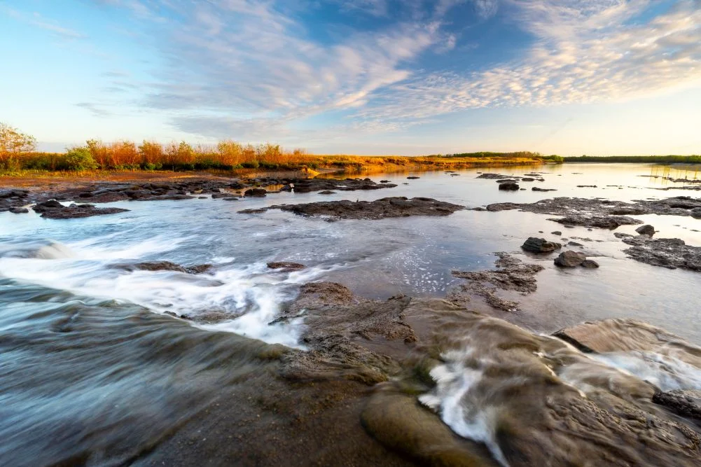
The Mary River National Park, situated approximately 150 kilometers east of Darwin via the Stuart and Arnhem Highways, stands as one of Australia’s most ecologically significant and densely populated estuarine crocodile habitats. Spanning a vast landscape of lily-fringed lagoons, verdant floodpains, dense monsoon forests, and mangrove-lined tidal reaches, the park commands a unique position in the Northern Territory’s tourism and conservation sectors. While the region is internationally recognized for its adrenaline-fueled jumping crocodile cruises closer to the urban center of Darwin, the remote wetlands of the Mary River offer a more primitive, immersive encounter with the Australian Top End’s apex predators, prolific birdlife, and premier barramundi fisheries. Managing an intricate balance between recreational tourism, historical legacy, and fragile wetland ecosystems, the park operates as a critical economic and environmental asset for the region.
Historical Background and Chronology
The recorded modern history of the Mary River region is deeply intertwined with the exploratory efforts of the 19th century. In 1862, pioneering explorer John McDouall Stuart reached the banks of the Mary River near the conclusion of his historic, cross-country expedition. Stuart successfully pioneered a 3,540-kilometer route from Port Augusta in South Australia to the northern coast near present-day Darwin, effectively opening up the Australian interior to overland communication and subsequent development. The campsite where Stuart rested near the river’s mouth was subsequently named Shady Camp in his honor.
For decades following Stuart’s expedition, the landscape remained largely undisturbed, utilized primarily by pastoralists and traditional Indigenous custodians who have managed Country for millennia. In the late 1980s, significant ecological intervention altered the hydrological dynamics of the region. A barrage was constructed across the Mary River at Shady Camp. The engineering objective of this skinny concrete dam was to prevent destructive saltwater intrusion from the Arafura Sea into the fragile, upstream freshwater habitats that sustained the delicate balance of the upper floodplains.
However, the barrage inadvertently created a unique convergence zone. While it achieved varying degrees of hydrological regulation, it failed to impede the movement of estuarine crocodiles and determined aquatic species. Today, the infrastructure acts as a focal point for both apex predators and human anglers, creating a dynamic ecological theater where seasonal run-offs from the long wet season purge the sodden marshes, driving aquatic life toward the sea and setting the stage for annual feeding frenzies.
Ecological Dynamics and Wildlife Management
The biodiversity of the Mary River Wetlands is characterized by extreme seasonal fluctuations. During the Top End’s wet season—extending generally from October to April—monsoonal rains inundate the floodpains, transforming the region into an expansive aquatic ecosystem. As the dry season commences in May, the receding waters trigger a massive migration of fish species, including prized barramundi, spotted saratoga, sooty grunter, and tarpon.
This annual purge subjects aquatic life to treacherous conditions as fish plunge over the Shady Camp barrage. Consequently, the site attracts substantial concentrations of estuarine crocodiles, locally known as "salties," which gather at the base of the structure to feed on disoriented marine life. Despite the proximity of these apex predators, the location remains a magnet for recreational anglers who navigate the shifting currents to cast lines from the banks and the barrage itself.
Beyond the aquatic predators, the wetlands support a remarkably dense avian population. The park is home to the comb-crested jacana—colloquially known as the "Jesus bird" for its ability to appear to walk on water across pink lotus lilies—alongside magpie geese, whistling ducks, jabirus, and myriad migratory shorebirds. The monsoon forests, accessed via trails such as the Jimmy Creek Monsoon Forest Walk (1.6 kilometers) and the Brian Creek Monsoon Forest Walk (2 kilometers), provide shaded refuge for agile wallabies, floodplain monitors, and orange-footed scrub fowls, which construct massive nesting mounds on the forest floor.
Infrastructure and Access Challenges
Managing access to a wilderness area subject to extreme monsoonal weather requires rigorous infrastructure maintenance by the Northern Territory Government. The park’s accessibility is heavily dependent on seasonal climatic patterns. Conventional vehicles can access the major campsites and viewing platforms during the dry season, typically from May through September, when temperatures range comfortably between 20 and 31 degrees Celsius. However, significant rainfall between October and April frequently triggers road closures due to severe flooding, cutting off vehicular access to remote outposts such as Point Stuart.
Park authorities, operating under the broader governance of the Northern Territory Department of Parks and Wildlife, enforce strict visitor management protocols to ensure public safety, particularly given the high density of estuarine crocodiles. Facilities within the national park include designated campgrounds at Shady Camp and Couzens Lookout. These sites offer basic amenities such as picnic tables, fire pits, and wheelchair-accessible toilet facilities. To maintain these remote locations, day-use entry fees are set at $10 per adult, with half-price rates for children, or $30 for a comprehensive two-week pass valid across all Northern Territory-operated national parks. Overnight camping incurs an additional fee of $10 per adult, $5 per child, or $25 per family, with visitors required to pack adequate supplies of drinking water and firewood.
Commercial Tourism and Economic Impact
The Mary River region serves as a vital economic engine for Top End tourism, driven by a combination of self-drive camping, recreational fishing, and commercial tour operations. Commercial entities such as the Point Stuart Wilderness Lodge provide alternative accommodation options, ranging from lodge rooms starting at $255 per night to fan-cooled safari tents from $215 per night. The lodge, alongside external operators like Wildlands and Corroboree Billabong Wetland Cruises, bolsters the regional economy by offering guided fishing safaris, boat rentals, and daily wetland cruises.
Commercial operators emphasize that water-based exploration is the most effective method for experiencing the remote reaches of the 30-kilometer wetland labyrinth. Polycraft boat rentals start at approximately $285 per day, while guided boat tours on Corroboree Billabong offer affordable entry points starting at $60 for adults and $40 for children. These excursions provide vital economic support to local communities along the Arnhem Highway, while simultaneously educating the public on safe wildlife observation practices in crocodile habitats.
Broader Implications and Conservation Outlook
The long-term outlook for the Mary River National Park hinges on balancing increasing recreational demand with rigorous environmental conservation. As visitor numbers rebound following the seasonal reopening of access roads, park management faces the ongoing challenge of mitigating human-wildlife conflict. Estuarine crocodile populations have rebounded significantly under decades of federal and territory protection legislation enacted in the 1970s, requiring heightened public awareness campaigns regarding water safety.
Furthermore, climate variability and rising sea levels present ongoing threats to the delicate equilibrium between the freshwater floodplains and the saltwater tidal reaches of the Arafura Sea. Conservationists and fisheries managers continue to monitor the ecological impacts of structures like the Shady Camp barrage, assessing their long-term efficacy in protecting endemic freshwater species against environmental shifts.
Ultimately, the Mary River National Park remains a testament to the resilience of Australia’s tropical north. By maintaining accessible yet strictly regulated wilderness areas, the region successfully accommodates thousands of anglers, naturalists, and campers annually, preserving an ancient landscape where natural history and modern outdoor recreation intersect.



 Tatiana Tantri Indah Sari
 Dwi Wanna
 Anjar Salim
 Lukman Taruna Persada Ramadan

 Budi Mulyono
